
Abel Tasman
The 1642–43 expedition led by Dutch explorer Abel Tasman sailed into Tasman Bay and probably sighted Rangitoto ki te Tonga (D’Urville Island), but substantial European acquaintance with Marlborough had to await British explorer James Cook and the Endeavour in 1770.
James Cook
Having almost completely circumnavigated the North Island, Cook brought the Endeavour to anchor at Ship Cove in the Marlborough Sounds on 15 January 1770, in the channel he named after Britain’s Queen Charlotte. The Endeavour stayed there for several weeks. An expedition to the highest point on the land opposite revealed both that it was an island (Arapawa or Arapāoa) and that a stretch of water separated the island from land in the distance. This waterway was to be named Cook Strait.
Cook then circumnavigated the South Island. ‘Lookers-on’ was his name for the Seaward Kaikōura Range. At the end of the journey the Endeavour made anchorage on 27 March in Admiralty Bay, adjacent to D’Urville Island.
Cook returned to Ship Cove on his second and third Pacific expeditions, in February and October 1773 and February 1777. In total he spent about one-third of his time in New Zealand waters at Ship Cove.
Whaling days
In the following decades it was whaling that brought Europeans into Marlborough, not timber or seals as elsewhere in New Zealand. Marlborough timber did not have as many uses as the kauri of the upper North Island, and seals were not plentiful.
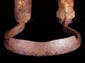
The peak period for whaling in Marlborough was the 1830s and 1840s. Shore stations hunted the right whale, which stayed close to shore, particularly when females were calving.
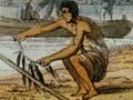
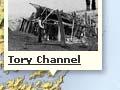
Jacky Guard’s station at Te Awaiti in Tory Channel dates from the late 1820s. Guard moved to Port Underwood, a more sheltered anchorage, in 1829; more shore stations followed in Cloudy Bay, and others on Tory Channel. Kaikōura saw a rush in the early 1840s as Guard (temporarily) and other Cloudy Bay whalers extended their operations.
These stations, as elsewhere in New Zealand, were places of trade and exchange between Māori and Pākehā. Māori frequently sold produce in exchange for metal goods, including guns. Intermarriage created more intimate ties between the two groups, and in the whaling gangs Māori and Pākehā worked alongside each other.
The intensive exploitation of the right whale, particularly of reproductive females and their calves, brought the inevitable demise of the industry after a few years. Some whaling continued into the 1920s in Kaikōura, and through to the 1960s in Tory Channel, as a minor part of the Marlborough economy.
Treaty and land ownership
The Treaty of Waitangi was signed by 27 chiefs at Queen Charlotte Sound on 4–5 May 1840, 13 on D’Urville Island on 11 May, and nine at Kākāpō Bay, Port Underwood, on 17 June. Immediately following the signing at Kākāpō Bay, British sovereignty was proclaimed over the South Island on nearby Horahora Kākahu Island.
An early attempt at cattle farming on the Wairau plain in mid-1840 was aborted when the four men involved vanished, and were never seen alive again.
In 1842 the European settlement at Nelson was established.
Wairau affray
Disagreement over land ownership led to conflict between settlers and Māori at Tuamarina. The New Zealand Company considered it had acquired title to all the land on both sides of Cook Strait – approximately one-third of New Zealand. Those chiefs who exercised mana over these extensive territories, notably Ngāti Toa leader Te Rauparaha and his nephew Te Rangihaeata, had in their view sold only very limited portions of it. In early 1843 surveyors were sent to the Wairau plain. Te Rauparaha and others protested that the area had not been purchased. They evicted the surveyors and burnt their huts. When an armed settler militia attempted to arrest the chiefs, a confrontation took place on 17 June 1843, and 22 Europeans and at least four Māori died. The incident was a shock to European settlers throughout the colony. It was clear that Pākehā did not have an uncontested claim to land in what was to become Marlborough.
The colonial authorities found in favour of Te Rauparaha and Te Rangihaeata, and in 1847 Governor George Grey ‘re’-purchased the Wairau from Ngāti Toa. The deed covered land as far south as Kaiapoi in Canterbury, although the tribe did not have rights on the coast beyond Te Parinui-o-Whiti (White Bluffs). The Kaikōura coast was purchased for £300 in February 1859, with the principal negotiation taking place between Ngāi Tahu leader Kaikōura Whakatau and James Mackay, the recently appointed assistant native secretary for the South Island.