Alpine Fault
The Alpine Fault runs for 650 km along the main north-east/south-west axis of the South Island, from Milford Sound to the coast near Blenheim. The longest active fault in New Zealand, it lies on a major tectonic plate boundary, where the Pacific and Australian plates collide and scrape past each other.
A house divided
In October 1848 an earthquake with an estimated magnitude of 7.5 shook Marlborough. The quake and its many aftershocks were caused by movement on a major fault in the Awatere valley. Along the fault, land moved as much as 8 metres horizontally. Matthew Richmond, the resident magistrate of Nelson, visited the area in November 1848. A report on his visit noted that ‘a crack quite straight crossed the country for miles; in some places he had difficulty crossing it with his horse; in one place the crack passed through an old warre [whare] dividing it in two pieces standing four feet [1.2 metres] apart.’1
The fault follows a different alignment through Marlborough from its main course further south, and is also known as the Wairau Fault. It shapes the course of the 168-km Wairau River.
Northern rocks
The rocks on the northern side of the Alpine Fault consist mostly of two zones of greywacke separated by a zone of schist (metamorphosed greywacke). These rocks are more than 200 million years old.
The rocks of this zone are similar to those found on the other side of the Alpine Fault, but nearly 600 km south, between Lakes Wakatipu and Te Anau (just as the rocks of north-west Nelson parallel those of Fiordland). These formations provide evidence of the extent of displacement along the Alpine Fault.
Volcanoes and glaciers
A belt of volcanic rock stretching as far as Rangitoto ki te Tonga (D’Urville Island) in the north contains a number of mineral deposits, including chromite, copper, serpentine and asbestos. Several thousand tonnes of chromite were mined in the 19th century. Copper has been prospected for, but found only sporadically and in small amounts.
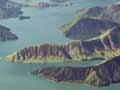
The mountain block forming the Richmond Range and related ranges tilted north-east at the beginning of a mountain-building period 15–20 million years ago. When the last ice age ended 14,000 years ago, rising sea levels flooded coastal valleys and formed the Marlborough Sounds.
Mountain-building
Greywacke is the dominant rock south of the Alpine Fault. These rocks are more recent than those north of the fault. The current phase of mountain-building has eroded younger sedimentary rocks to expose the greywacke.
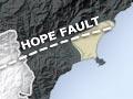
In the last 10 million years, faulting caused by the subduction of the Pacific Plate under the Australian Plate has extended beyond the Alpine Fault. The Awatere and Clarence faults have shaped the courses of the Awatere and Clarence rivers. The impact of the Kēkerengū Fault can be seen in the Clarence River’s 12-km course southwards before reaching the ocean, and that of the Hope Fault in the alignment of the Kaikōura plain.
Glaciation also influenced the shape of the ranges and valleys between the mountains. The volume of debris and the relatively shallow gradient of the rivers at lower altitudes have made their courses braided, as in Canterbury.
Plains and coasts
The alluvial valleys of the Wairau and Awatere rivers are the most recently formed parts of Marlborough. The Wairau valley was mostly swamp until flood-control measures were put in place.
The Wairau Bar, a bank of gravel where the river meets the sea, was first formed when the shoreline reached well inland at the end of the last glaciation, around 14,000 years ago. A north-flowing coastal current deposited gravel and other materials in the shallow waters, slowly forming the bank. Behind the bank, the river dumped sediment until the bay filled in. The current boulder bank is the latest; the many other shorelines were further inland.
Lake Grassmere (Kāpara Te Hau) is an old bay that has become cut off from the ocean due to uplift (found along the whole Kaikōura coast).
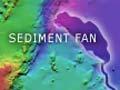
The alluvial plain at Kaikōura joins a limestone outcrop which was once an island to the mainland, forming the Kaikōura peninsula. The marine Kaikōura Canyon is an outlier of the Hikurangi trench, where the Pacific Plate is subducting under the Australian Plate. Its abyss-like depths of around 1,750 metres bring sperm whales to within a stone’s throw of the peninsula.