

Māori and early Pākehā
It is likely that only a few hundred Māori lived in Marlborough in the first half of the 19th century, and many of them, particularly those who had recently settled there from the North Island, moved between their new home and their older home across Cook Strait. The whaling stations at Port Underwood, Kaikōura and other localities brought some Pākehā to the region, but the total population would not have altered much because the Māori population was decreasing.
A continuous history of Pākehā settlement dates from the 1850s. The heart of Marlborough developed on the Wairau plain. A major earthquake in 1855 deepened the Ōpawa River, allowing vessels to navigate some distance upstream. Landowners subdivided and a town developed, named ‘the Beaver’ on account of the watery nature of its site. Its name was later changed to Blenheim. By 1857 it had a courthouse, a post office, plans for a customs house and a substantial wool trade – in 1857, 103 coastal vessels took £51,000 worth of bales across Cook Strait to Wellington.
A farming population
Small-scale grain and vegetable farming developed on the Wairau plain, on the plains around Kaikōura after the 1870s, and in the Awatere valley after some large runs were subdivided in the 1890s and 1900s. The northern hill country supported a farming population in the valleys, but the deforested hills reverted to bush. The population of Sounds county was static and then declined from its 1911 peak of around 1,200.
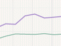
The rural population of Wairau and Awatere counties increased from just over 6,000 in 1896 to nearly 8,500 by 1916. After this there was relatively little purely rural growth – most took place on the margins of Blenheim.
Intermittent surges of population accompanied the Wakamarina gold rush (1864) and railway building to Blenheim (1870s and 1890s to 1900s) and Kaikōura (1936 to 1945).
Blenheim’s growth
In 1878 Blenheim had a population more than double that of Picton (1,781 compared with 703). It retained that lead through years of steady growth in the 20th century, reaching nearly 5,000 by 1926. Growth slowed after that, then resumed during the Second World War, partly because of the establishment of the Woodbourne air base. Blenheim’s population reached 12,000 in 1961, and 29,298 in 2013.
In 2013 Blenheim’s economy was dominated by the farming, manufacturing, health and retail sectors; the professional, financial and educational sectors were relatively underrepresented compared with the national averages. Professionals and managers were also underrepresented and labourers overrepresented.
Māori in the 20th century
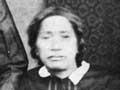
Despite a vigorous history, the Māori population of Marlborough was not large in the mid-20th century. In 1961 there were 690 Māori – proportionally the largest Māori population of any South Island region. Many lived in the Māori settlements at Waikawa and Kaikōura.
In 2013, 11.4% of Marlborough’s population identified as Māori. The majority lived in Picton, Kaikōura and Blenheim. Māori were the only significant ethnic minority – 85.2% of the region’s population identified as European. (Multiple responses were allowed.)
Population distribution in 2013
The total regional population was 46,968 in 2013. Marlborough district had a population of 43,416 (10% higher than in 2001), of whom 35,478 were in the Wairau. Much of the increase was in the vicinity of Blenheim. In 2013 Kaikōura district’s population was 3,552, of whom just under 2,000 lived in the town.