


Story summary
Geologists study the earth’s structure and history by looking at rocks and other features, from hot springs to icy glaciers.
European explorers
Many people who came to New Zealand from Britain and Europe in the early 19th century explored remote valleys, mountains and thermal regions. Scientists made sketches or wrote about what they found, such as moa bones and earthquake zones.
Between 1839 and 1841 Ernst Dieffenbach, from Germany, explored the North Island. He wrote about rocks, volcanoes, plants and animals, and Māori culture.
Searching for gold and minerals
In the 1850s miners found gold in Coromandel, and soon every region wanted to know if gold, coal and other valuable minerals lay in the ground. Geologists were paid to join the search, including:
- Ferdinand Hochstetter, an Austrian geologist, who looked for coal in South Auckland, and collected fossils and rocks. He wrote the first major report on New Zealand geology.
- Julius Haast, from Germany, who explored the North Island and Nelson with Hochstetter. He found coal on the West Coast. In 1863 he crossed the Southern Alps, and wrote about the glaciers. The route he took is called Haast Pass.
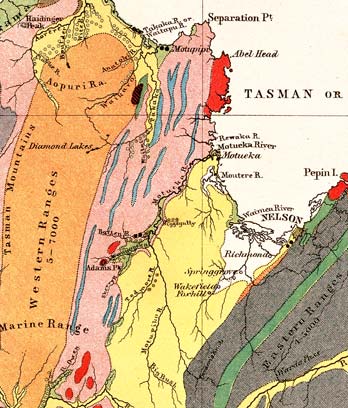
- Scotsman James Hector, who explored Otago during the 1860s gold rushes. He collected rocks and fossils, and made the first map of New Zealand’s geology.
Field work and mapping
From the early 1900s, geologists spent months camping in remote places. They explored, sometimes on bikes, and took notes. By candlelight they wrote reports and made maps. They aimed to map the whole country, showing volcanoes, fault lines, minerals and other features.
The sea floor
By the 1940s, scientists knew how to measure the depth and shape of the sea floor around New Zealand. Surveys showed that there were canyons, valleys and volcanoes under the sea.
Geologists and geophysicists then searched beneath the sea floor for natural gas and oil. Drilling began at the Māui gas field (offshore from Taranaki) in 1969.
Earthquakes
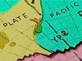
New Zealand is earthquake territory. By the 1950s geologists knew that New Zealand’s quakes occur in certain zones. Since then they have shown that the country lies on two big ‘plates’ of rock that are pushing against each other.