

J. M. Bell: detailed mapping
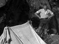
In 1904 a young Canadian geologist, James Macintosh Bell, became director of the Geological Survey, and applied the field experience he had gained in Canada. Whereas earlier geological surveys had been sketchy, Bell decided that detailed maps would have a scale of 1 inch to 1 mile (1: 63,360), with the aim of covering the whole country. No topographic maps were available, so surveyors were included in the field parties. As in North America, field work became a major expedition, with a large group (including field hands and a cook), camping equipment and supplies.
Although Bell only served from 1905 to 1911, he established a tradition of detailed mapping that lasted 50 years. But progress was slow, and staff were often transferred to economically productive projects.
Field work
The pattern of field work remained almost unchanged until the 1940s. Geologists spent five to seven months each year in the field, often under canvas. They worked every fine day, and were supposed to cover about 30 square miles a week. Evenings were spent plotting observations by lantern or candlelight. After financial cutbacks in the 1920s and 1930s, wives worked as cooks and camp organisers.
Most geologists used bicycles for transport, although a local farmer or transport service might be paid to help move camp. Winters were spent in Wellington, writing reports and preparing maps for publication.
Studying volcanoes
In 1920 Thomas Jaggar, director of the Hawaii Volcano Observatory, reported on the need for a volcanological observatory in New Zealand. As a consequence Leslie Grange made detailed maps of an enormous area between Rotorua and Mt Ruapehu. He became interested in the ash deposits of the region, where stock were suffering from a wasting condition called ‘bush sickness’. Grange and N. H. Taylor showed that ash from the Taupō and Kaharoa eruptions lay beneath the area. It was later recognised that the ash and pumice were deficient in the trace element cobalt. When this was added, animals thrived.
An economic focus: 1930s
In the late 1930s the government pushed to replace imports with local materials. Geological investigations focused on assisting the gold mining industry, and investigating coal resources and a steel industry.
With the outbreak of the Second World War, almost all geological work was aimed at replacing imports. This also brought scientific rewards. On an expedition to South Westland to locate mica (needed for radio capacitors), geologists Harold Wellman and Dick Willett recognised the Alpine Fault for the first time. Although this is a huge feature that bisects the South Island, it had been overlooked by scientists doing detailed mapping.
The birth of geophysics
Geological investigations had traditionally focused on rocks visible at the surface or tested by drilling. Geophysics was a method of working out the geology beneath the surface without actually touching the rocks. Introduced in the 1930s under the sponsorship of Ernest Marsden (secretary of the Department of Scientific and Industrial Research), geophysical techniques were used in New Zealand to explore for buried gold-bearing gravels and other underground mineral deposits. It was soon clear that geophysical prospecting saved time and could be used in identifying dam sites, underground water supply and a variety of engineering projects. A Geophysics Division of the department was set up in 1951.
A complete geological map
By 1955 only about one-third of the land area had been covered by geological maps, some of which were already obsolete. It was clear that the national geological survey, begun nearly 100 years earlier in 1865, would never be completed. Dick Willett, newly appointed as director of the Geological Survey, focused on a short-term project – a less detailed geological map of the whole country, at the scale of 4 miles to 1 inch (1:250,000), and concentrating new field work in places that were poorly known. Within 10 years, 28 maps were published. An up-to-date geological map of New Zealand was completed in 1965, in time for the 100th anniversary of the New Zealand Geological Survey.