


Remote sensing
Until the Second World War, geologists studied only the surface of the land. With new technology, they could study deeper rocks on land, and look beneath the sea. To do this they used various methods of remote sensing – seeing the rocks without touching them.
Shape of the sea floor
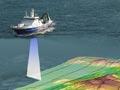
Detailed charting of the New Zealand coastline was completed by 1855, but there was little information on the shape of the sea floor, except for measurements in shallow water. For almost a century knowledge of the sea floor remained minimal, apart from scattered soundings that indicated widely varying depths. The continuous-recording echo-sounder, developed during the Second World War, meant that depth measurements could be gathered rapidly.
Interest in marine resources after the Second World War led to the establishment of the New Zealand Oceanographic Institute, a branch of the Department of Scientific and Industrial Research. One of the first jobs was collating bathymetric data (depth measurements) to determine the shape of the sea floor. A bathymetric map published in 1964 showed that beneath the sea, the land around New Zealand extended offshore to form an enormous continental margin, more than 10 times the land area above sea level. The new bathymetric map revealed that further offshore there was a pattern of submarine canyons, troughs, irregular slopes, and volcanic seamounts. It was found that the continental margin represented submerged continental crust that was likely to have rocks similar to those exposed on land.
Sedimentary basins
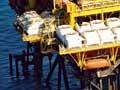
Although several oil seeps were known, exploration for hydrocarbons (which make up oil and other fossil fuels) was not successful in the 19th and early 20th centuries. In the early 1950s Shell BP Todd made seismic surveys in Taranaki, and the Kāpuni gas field was discovered. It was suspected that beneath the continental margin there were sedimentary basins that might contain oil and gas, but marine seismic surveys were required.
The Continental Shelf Act 1964 authorised offshore prospecting for petroleum, and in the succeeding decade most of the continental shelf was explored. As anticipated, sedimentary rocks were found to lie under much of the shallow continental margin. A number of distinct sedimentary basins have been recognised. Although the Māui gas field is the only offshore site so far exploited, several other oil and gas prospects are known in offshore Taranaki, and there is potential for further discoveries as more detailed exploration is undertaken.
Understanding earthquakes
Earthquakes were regarded as a curiosity in the first part of the 20th century. Between 1913 and 1926, the New Zealand Official Yearbook annually commented that ‘earthquakes are rather a matter of scientific interest than a subject for alarm’. Opinions changed after the damaging 1929 Murchison and 1931 Hawke’s Bay earthquakes, and a small government seismological network was set up.
Earthquake zones
As seismological methods for determining the epicentre of earthquakes improved worldwide, it became clear that earthquake activity was confined to narrow zones or belts. The circum-Pacific belt ran through New Zealand, and seismologist R. C. Hayes recognised that the shallower earthquakes occurred on the Pacific (eastern) side, while deeper earthquakes were further west.
Although there were ongoing arguments about the cause of earthquakes, by the 1950s there was evidence for an eastwards-sloping zone of earthquakes underneath the North Island, later named a Benioff zone. It was found that crust from the Pacific Ocean was being pushed (subducted) beneath the North Island, and that this was the cause of many of the deeper earthquakes.
Faults
Geologists have found that the New Zealand crust is splintered into a jigsaw of blocks, separated by cracks or fractures known as faults. Evidence from offset river terraces showed that some faults have moved repeatedly, causing large earthquakes. New Zealand scientists have become leaders in paleoseismology – the study of past earthquakes.