
2013 population: 46,437
Nelson is the largest urban area in the upper South Island, and gives its name to the island’s north-west region. The city is the region’s commercial, cultural and industrial centre, and half of the region’s residents live in the city or its suburbs. Nelson city is bordered to the west and south-west by the Tasman District Council and the east and south-east by the Marlborough District Council. The city does not include Richmond, the region’s second-largest settlement.
The site of the city was chosen in 1841 as it had the best harbour in the region – Nelson Haven – and was close to the fertile Waimea Plains. The city was initially built upon the swampy river flats of the Maitai River, and its suburbs spread onto the low surrounding hills.
Nelson is bounded by hills to the east. These rise steadily to the tops of the Richmond Range, which separates Nelson and Marlborough. Most of the city’s water supply comes from dams on the Maitai and Roding rivers. With little flat land, many houses are tucked into small valleys, by humps and hollows. Suburbs and localities have English names such as The Wood, The Glen and The Brook. A walkway from the Brook Valley follows the line of New Zealand’s first railway, which served a copper mine on Dun Mountain in the early 1860s.
‘Kiss me Hardy’
Nelson is named after the British naval commander Horatio Nelson. An English settlement, the city has many names that make a nod to the mother country and to Nelson’s sea battles – including Albion Square and Britannia Heights. The main street is Trafalgar Street, after the 1805 battle in which Nelson died. His final words were reputedly ‘Kiss me Hardy’. Thomas Hardy was the flag-captain and a close friend of Nelson’s. Fittingly Nelson has a Hardy Street, at right angles to Trafalgar Street.
Early city history
Māori have lived in the region since the 1300s, and knew the area that is now Nelson city as Whakatū. The sheltered waters beyond the Boulder Bank were also well-known to Māori. The shore had been settled at times, but had no permanent settlements in the early 1840s, when Europeans arrived.
Clay for early European huts was puddled (worked) with feet, and wooden structures went up once pit-saws were established. Houses of artisans and the well-off were next to tanneries, breweries, workshops and shops. In 1858 Nelson became a city when Queen Victoria made it the seat of an Anglican bishop. Yet it had just over 5,000 people, and cattle still wandered the streets.
Nelson grew very slowly from the 1860s until the 1950s, when population growth increased and new suburbs developed.
The CBD
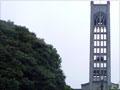
Nelson city is very compact and most things are within walking distance. The central business district centres on Trafalgar Street, the main shopping street. Nelson’s dominant landmark is Christ Church Cathedral, on Church Hill at the head of Trafalgar Street. In the 1980s the central streets were beautified and made more pedestrian-friendly. Coffee stalls are common on street corners and on Saturday mornings a market is held in Montgomery Square.
Across the Maitai River is 147-metre Botanical Hill. This is often described as ‘the centre of New Zealand’, but the country’s real geographic centre is further south, near Tapawera. The sports field at the base of the hill was the site of New Zealand’s first rugby match, between Nelson College and the Nelson Rugby Football Club on 14 May 1870.
Sleepy Hollow and Hokey Pokey
Wakapuaka, on the northern shores of Nelson Haven, was known to early Pākehā settlers (who probably couldn’t pronounce it) as ‘Hokey Pokey’. Nelson was ‘Sleepy Hollow’, as it was such a quiet town.
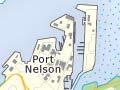
The port
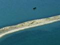
The port has been critical to Nelson’s economic development, given the lack of other easy transport options. The imports and exports that flow through it are the city and region’s life blood. ‘The Cut’ (the harbour entrance), which was created through the Boulder Bank in 1906, was deepened and widened by dredging in the 1960s. The spoil was used to reclaim land for coolstores, ship yards, oil tanks and other port facilities. This reclaimed land adjacent to the port is the main industrial centre close to the city.
Whakatū marae, near the shores of Nelson Haven, was opened in 1995 and represents the six land-holding iwi of the region. Next to this is Founders Park, a heritage park which features a replica townscape of Nelson as it was from the 1880s to 1930s.