Kahurangi National Park
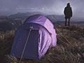
Kahurangi National Park, at 452,002 hectares, is the country’s second-largest national park (after Fiordland). It was created in 1996 and takes in almost all of the mountain lands of north-west Nelson. Around half of the park is in the Nelson region and half in the West Coast region. It offers tramping, caving, brown-trout fishing, hunting, rafting and kayaking, with almost 50 huts and thousands of kilometres of tracks and routes.
Before 1996 most of this mountainous forested country was managed as Northwest Nelson Forest Park (created in 1970 by amalgamating eight regional state forests). A large part of the central western part of the park is managed as the Tasman Wilderness Area.
Extensive prospecting and mining have occurred in the north-west Nelson mountains. Many of the open tops, such as the Mt Arthur Tablelands, the Cobb Valley, the Thousand Acres Plateau and the area around Boulder Lake, were burned and grazed in the late 1800s and early 1900s. The main access points to the park from the Nelson side are the Flora Saddle (near Motueka), the Wangapeka valley, the Matiri valley (near Murchison), the Cobb valley and the Aorere valley road-end (the start of the Heaphy Track).
Cobb River valley
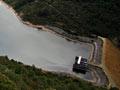
A prospector by the name of Cobb gave his name to this elevated valley in the mountains at the head of the Tākaka Valley. Planning for a hydroelectric scheme began in the late 1920s when the Hume Pipe company became interested in exploiting nearby asbestos deposits. The scheme was taken over in the late 1930s by the government. The river was dammed and water piped down to a power station adjacent to the Tākaka River. Water drops 593 metres – the highest vertical fall for any hydro station in the country. The road that serves the dam is one of the main access points to Kahurangi National Park.
Heaphy Track
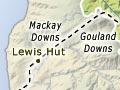
The Heaphy Track begins at the end of the Aorere valley road and leads to the West Coast. The route has long been touted as a road linking Golden Bay to Karamea. In the late 1960s and early 1970s the Ministry of Works conducted a Heaphy Highway survey. Local bodies in Golden Bay and the West Coast pushed for a road – the preferred route was Kahurangi Point to the MacKay Downs, then to Lewis Hut and down to the Heaphy River mouth, then along the coast to Kōhaihai. This road would have eliminated part of the Heaphy Track. The project stalled due to lack of government funding and growing public opposition.
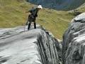
Lord of the rocks
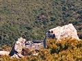
The bizarre rock outcrops of Mt Owen – one of the best examples of a glaciated karst landscape in the world, along with those at Mt Olympus in the Aorere River valley – were scene locations in the Lord of the rings film trilogy.
Mt Arthur and Mt Owen
These marble mountains dominate the western outlook from Nelson city and are often snow-covered in winter. Mt Owen has the longest caves in the country, and Mt Arthur has the deepest. A pack track leading up to the Flora Saddle gave early graziers access to the tablelands and the Cobb River valley. Prospectors also worked the area, their numbers rising briefly during the 1930s when a government work relief scheme bankrolled them. The Flora Saddle offers easy access to the vast Karamea catchment via the track down the Leslie River.