

Onekakā and coastal settlements
Stretching along the road and coast from Tākaka to Collingwood are the small locales of Patons Rock, Puramāhoi, Onekakā, Tukurua, Parapara and Milnthorpe. As well as farmland there are houses, artisans’ studios, a micro-brewery and live-music venue (the Mussel Inn at Onekakā), and places to stay. The rusting and rotting piles at the western edge of Onekakā inlet mouth mark the remains of Onekakā wharf, which served the old ironworks.
Collingwood
2013 population: 231
Collingwood is Golden Bay’s oldest and second-largest town. Gold was discovered nearby in 1857, and some people suggested that the town should become New Zealand’s capital. The town was surveyed on terraces on the eastern side of the Aorere River mouth, but Collingwood – originally called Gibbstown – was never built there. Instead settlers established themselves on the flat land below. The town’s wooden buildings were damaged or destroyed in major fires in 1883, 1897, 1904, 1930 and 1967.
Western Golden Bay gets more rainfall than the east, and dairy farming is the main activity alongside tourism. Mt Burnett, overlooking Collingwood, is the only source of dolomite in New Zealand. This is quarried and is used mainly as an additive to phosphate fertilisers. Solly’s, an important trucking firm in the bay, was established in Collingwood in 1928 – a time when the trip to Nelson by truck took 16 hours.
Aorere valley
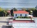
The road up the Aorere River is a dead end, which finishes at the start of the 78.4-kilometre Heaphy Track. Trampers walk this in three to four days to reach Karamea on the West Coast. The valley flats are mainly dairy farms. Langford’s store at Bainham opened in 1928, and in the 2010s remained an old-fashioned country store. The locality takes its names from its first European settlers, Bain and Graham.
Red boys
Hec Shaw remembered playing in the abandoned paintworks at Pākawau with his brother. Covered in red ochre, the boys ‘thought we had a good day until we met Mum’.1 They were sent to the freezing-cold creek to scrub their bodies and clothes with caustic soap.
Pākawau
Coal seams were worked at Pākawau from the 1840s. All transport was by boat, and jetties were built. In the 1860s trial shipments of plumbago (graphite) were sent to England. Pākawau also had paintworks in the early 20th century. In 2010 there were houses, baches and a pub/café.
Pūponga
Coal seams were worked at Pūponga from the late 1890s. Its location at the base of Farewell Spit offered sheltered waters for shipping, but the old wharf is long gone.
Buried treasure
On 7 August 1877 the Queen Bee was wrecked on Farewell Spit. The cargo broke up and the shore was littered with flotsam – including a 30-gallon (136-litre) barrel of whisky. A hopeful early settler couldn’t get the barrel into his dinghy, so he rolled it up the beach, buried it, and marked the spot with a stick. He returned with a larger dinghy, but – alas – the tide had washed his marker away.
Farewell Spit
New Zealand’s longest sand spit extends some 32 kilometres eastward from Cape Farewell. It has been formed by sand drifting up the west coast and being deposited in the calmer waters of Golden Bay. The spit was named by British navigator James Cook in 1770 as he was leaving the coast. Cape Farewell is the northernmost point of the South Island, with a latitude similar to Levin in the North Island. The spit is renowned for its bird life – and for whale strandings; more than 400 pilot whales standed on the spit in 2017..
Māori knew Farewell Spit as Onetahua. They used to camp at its base and portage (carry) their waka across the dunes when travelling to or returning from the West Coast. The Department of Conservation runs Pūponga Farm Park at the base of the spit and this has many short walks. No private vehicles or bikes are permitted on Farewell Spit. Foot access is allowed for 4 km on the ocean beach and 2.5 km on the inner beach, and guided vehicle trips go out to a lighthouse near its tip.
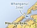
Whanganui Inlet
Whanganui Inlet (also called Westhaven), on the west coast, is one of the largest estuaries in the South Island. It was well known to early skippers who would put into the harbour to escape westerly storms. As flax mills and sawmills were established in the late 1800s, ships called to take away cargo. It is a largely unmodified estuary – the southern third is a marine reserve and the rest is a wildlife reserve. The road skirting the eastern shore, Dry Road, originally crossed mudflats and could only be used at low tide. It leads to the remote settlement of Mangarākau. While the road continues for about 10 kilometres beyond the Paturau River, a ford there means it is only suitable for four-wheel drives. Sheep farms continue as far south as Big River.