Murchison
2013 population: 492
Murchison is Nelson’s largest inland town, often referred to as ‘Murch’. It is a rural servicing centre for the surrounding valleys, where dairy farming is the main industry. Murchison was a heavily wooded flat in 1846. The discovery of gold triggered settlement, and the township – then called Hampden – was surveyed in 1865. Its name was changed in 1882 to avoid confusion with the town of the same name in North Otago.
The town was also a staging post on the route from Nelson to the West Coast – from Murchison, State Highway 6 goes through the Buller River gorge to Westport. State Highway 65 branches off this, following the Maruia valley to Springs Junction and Maruia Springs before ascending Lewis Pass to Canterbury.
River sports
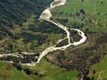
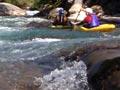
The town has long been a popular stopping point en route to the West Coast or Canterbury, and tourism has become important. White-water kayaking is popular on rapids in the Buller River and its tributaries. Murchison is home to the New Zealand Kayak School, which claims that the town is the ‘whitewater kayak capital of New Zealand’1. Within 20 minutes’ drive there are 14 runs ranging from class I (easy) to class IV (difficult) on the Buller, Matiri, Mangles, Mātakitaki and Maruia rivers. Trout fishing is also popular.
Earthquake country
On 17 June 1929 a magnitude 7.8 earthquake struck the northern South Island near Murchison. The shaking triggered dozens of huge slips on the steep mountain slopes, which were waterlogged from winter rain. Landslides blocked many rivers, killing four people in the Mātakitaki valley and five in the Maruia valley. Roads were so badly damaged that vehicles could not reach Murchison for several months.
Where’s Jill?
In the late 1800s tracks were rough, and wagoning was a hard job attracting hard men. The group who hauled the first gold dredge into the Mātakitaki River valley – Jack Hagan, Joe Fowler, Jack Maude and Jack Mead – were known as ‘the four Jacks and no Jill’.2
Mātakitaki River valley
Gold was discovered in the Mātakitaki River valley in 1863. A walking track 10 kilometres up the valley gives access to the Six Mile hydroelectric plant, built in 1922. The head of the Mātakitaki River valley and the nearby Tūtaki River valley give good tramping access to lesser-used parts of Nelson Lakes National Park. The valley floor is farmed.
Maruia River
The Maruia River is a tributary of the Buller River. The Maruia Falls formed after a landslide caused by the 1929 Murchison earthquake shifted the river’s course – it flowed over an old river bank and eroded the gravels beneath, over time forming a waterfall with a 10-metre drop.
Matiri River valley
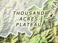
The Matiri River valley flats are farmland. The road end at the head of the valley offers access to Lake Matiri and the Thousand Acres Plateau and nearby Hundred Acre Plateau (also dubbed the ‘Devil’s Dining Table’), and other earthquake-shattered landscapes in Kahurangi National Park.