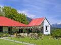
Tophouse
The original ‘Top House’ was the farthest-inland accommodation house on the overland route from Nelson to Blenheim, near where the route from Nelson reaches the Wairau Valley. The house was built in 1859. In a time before good roads these houses were vital stopover points for travellers.
Kawatiri and Gowanbridge
Kawatiri (the Māori name for the Buller River) was the end of the line for Nelson’s planned railway, the Midland Railway Line, which was intended to join the line up the Grey Valley to Īnangahua. It ended up being a railway to nowhere – the line reached Kawatiri in 1920, and although a further 6-km section was built to Gowanbridge it was only ever used for freight.
Kawatiri also marks the point where State Highway 63 branches off State Highway 6 to St Arnaud and onwards to Blenheim down the Wairau valley. At nearby Gowanbridge the Buller River meets the Gowan River, which drains Lake Rotoroa. A bridge over the Buller leads to the lake.
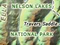
Nelson Lakes National Park
St Arnaud
On the shores of Lake Rotoiti is the tourist town of St Arnaud, with a population of around 200. St Arnaud is the main gateway to Nelson Lakes National Park (created in 1956). Camping at Rotoiti was popular from the early 1900s, and by 1925 cottages were built. There is a Department of Conservation campsite at Kerr Bay on the shores of Lake Rotoiti and another one at the outlet of Lake Rotoroa. Lake Rotoiti is an hour and half’s drive from both Nelson and Blenheim. The quickest access from Nelson city to St Arnaud is via Tophouse.
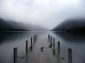
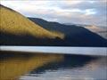
Lakes Rotoiti and Rotoroa
The national park includes two large glacial lakes – Rotoiti and Rotoroa – and the mountains and valleys to the south. The first Europeans to see these lakes were Charles Heaphy, Thomas Brunner and William Fox, who explored from Nelson as far as Murchison with Māori guide Kehu in 1846. Lakes Rotoiti and Rotoroa have largely unmodified catchments, so their water clarity is exceptional. The Buller River’s source is Lake Rotoiti. The upper tributaries of the river, including the lakes, are protected by the Buller National Water Conservation Order (1996). The river and its tributaries offer excellent brown trout fishing.
Tramping and skiing
Water taxis take trampers across both lakes, and tracks skirt their eastern shores. The most popular walk is the Travers–Sabine tramping circuit, which takes four to seven days. There are many other tracks and 22 huts in the park. Mountains in the national park are similar to those of Canterbury, with scree slopes of greywacke. They are higher than the other Nelson mountain ranges, with peaks rising over 2,000 metres. Avalanches are common in winter. Mt Robert (1,421 m), in the Travers Range overlooking St Arnaud, had a skifield from the 1940s. It closed in 2005, as the altitude was too low for reliable snow.