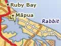

Māpua and Ruby Bay
2013 population: 2,013
These two small settlements sit near where the main road from Nelson to Motueka meets the coast after crossing the Waimea Plains. Māpua was an important coastal port, and many shipments of apples left from its small wharf on the western entrance of the Waimea Inlet. The wharf area has become a tourist centre, with restaurants, shops and galleries occupying the old cool store and other warehouse buildings.
In 1945 the Fruitgrowers Chemical Company, next to Māpua port, began producing organochlorine pesticides. Chemicals contaminated the soil, groundwater and sediments in the nearby estuary. The plant closed in 1988, and in 1999 the government helped the Tasman District Council fund its cleanup, which was completed in 2007. A public park was planned for the site.
The Māpua Leisure Park campground offers a clothing-optional season for naturists every February and March. Ruby Bay, 3 kilometres from Māpua, has a safe, sandy swimming beach.
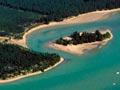
Rabbit Island
Rabbit Island (known as Moturoa to Māori) is a barrier island which separates the waters of Waimea Inlet from Tasman Bay. Planting of pines began in 1921, and the island is covered in exotic forests. Its 11-km beach is popular in summer.
Moutere Hills
The Moutere Hills, behind Māpua and Ruby Bay, were mostly orchard-covered by the late 1920s. The 1930s economic depression brought hard years for apple growers, and many orchards were ripped up and planted out in pine forests. The Woollaston Estates vineyard at Mahana was formed in 2000 by a group including Philip Woollaston, son of Toss Woollaston (the region’s most famous painter). It hosts art exhibitions and has a sculpture park.
Sun lovers
Nelson’s sunny climate attracts many people – from those who want to retire, to holidaymakers, alternative lifestylers and naturists. The nudist Nelson Sun Club has its base in the Moutere Hills.
Upper Moutere
Upper Moutere is a township in the upper Moutere valley, 18 km south of Motueka. German immigrants settled here in 1843 but winter floods forced them out of the upper valley to Waimea and Ranzau (later called Hope). Some returned later, and they retained their language and culture up until about the 1900s. Germans brought the first grapes into the region. Upper Moutere was known as St Paulidorf, and also as Sarau, after a town in northern Germany. During the First World War Germans were pressured to share their fellow New Zealanders’ allegiance to Britain. German names were anglicised and Sarau became Upper Moutere.
Lower Moutere
Lower Moutere is a farming locality in the lower Moutere valley, 6 km from Motueka, close to the Moutere Inlet. The road up the valley to Upper Moutere offers an alternative to the main route (State Highway 60) between Nelson and Motueka. The Riverside community in Lower Moutere was established in 1941 by a small group of Methodist pacifists. It operates a dairy farm and café. In 2013 some 24 people were permanent members, and 19 children lived there, but the community’s population sometimes doubled due to WWOOFers (Willing Workers on Organic Farms) and other visitors.
Tasman
Tasman is a locality among apple orchards on the shores of Moutere Inlet. Small stones are laid out on the inlet’s mudflats at low tide, forming ever-changing names, messages and pictures. Nearby Kina is a small beach settlement on Tasman Bay.