Southland consists of three distinct landform regions, which have different geologies.
The uplands
The mountains in the north of the region are part of the block of schist which forms Central Otago. This region is similar in geological composition to north-west Marlborough. The movement along the Alpine Fault has now separated the two areas by 500 kilometres, but the earlier overlap can be seen in the patterns of rock.
The Southland Syncline
The Southland Syncline, a colossal fold in the earth’s surface, is caused by tectonic activity. It reaches from the Tākitimu Mountains to the Catlins coast. The Hokonui Hills, a part of this syncline, were thrust up a few million years ago.
The plains
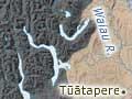
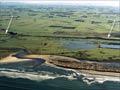
The Southland plains extend from the mouth of the Waiau River in the west to the boundary with Otago in the east. The plains are flanked by the Hunter and Tākitimu Mountains to the north-west, and the Eyre and Garvie mountains and the Hector Range to the north. The Hokonui Hills divide the main Southland plain from the Waimea Plains.
There are three main areas:
- The Southland plain proper extends from the Mataura River to the Aparima River.
- The Waimea Plains lie between the high country and the Hokonui Hills.
- The lower Waiau plain lies between the Longwood Range and Tākitimu Mountains to the east, and Fiordland to the west.
Fiordland
Fiordland is a block comprised mostly of gneiss, a rock that has metamorphosed from other rock types, notably granite and diorite (also found in Fiordland). These rocks, some of the oldest in New Zealand, date from the Ordovician period, more than 400 million years ago.
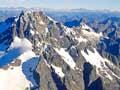
The Fiordland terrain was scoured by glaciations during the last ice age, between 75,000 and 15,000 years ago. That created the coastal fiords and the inland lakes, from Te Anau south to Hakapōua. Mt Tūtoko, north of Milford Sound, is the region’s highest summit at 2,746 metres. Most of the peaks further south are between 1,400 and 2,200 metres.
Soils
The Southland plains comprise mostly yellow-brown earths, the product of river deposits, with the most recent soils in the lower valleys of the Mataura and Ōreti rivers.
High rainfall causes nutrient leaching, so farmers add fertiliser, especially in northern Southland. On low-lying river soils, drainage is needed.
Fiordland soils are podzolised gley (waterlogged) and organic soils, but large areas on the summits of the ranges are bare rock, scree and ice.