Early travel
Prevailing westerly winds made the Melbourne–Bluff route a favoured approach to New Zealand in sailing days, although ships sometimes had to contend with contrary winds in Foveaux Strait. Land transport from Bluff to Invercargill had to take account of the tides at the narrow neck of the Bluff isthmus.
The railway arrives
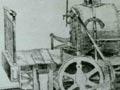
The first railway in the south was built in 1864, of locally milled kahikatea (white pine). It ran between Invercargill and Makarewa and was part of a scheme to improve access to the Wakatipu goldfield. Wooden rails tended to warp, and when gold seekers moved on, the line was abandoned in 1866.
But railways had come to stay. A workshop opened in Invercargill in 1868. During the 1870s, railways were built from Invercargill to Lumsden, Kingston, Ōtautau and Riverton, and between Lumsden and Gore. Dunedin and Invercargill were linked in January 1879. By 1911 branch lines operated to Hedgehope, Mossburn, Nightcaps, Tūātapere, Glenham, Waikaia, Waikākā, Tokanui and Ōhai.
Electricity
Rural Southland set up the country’s first electric power board, with a mandate to provide power to country areas as well as towns.
Southland built its own power station at Lake Monowai. By the time the station opened in 1925, more than 5,300 kilometres of power lines had been strung – far more than in any other part of the country. By 1930 all settled parts of the province were reticulated.
But the scheme was overambitious, and the board went bankrupt in the 1930s depression. The government took over, and Southland became the only part of New Zealand without a local electricity supplier.
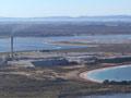
Manapōuri power station
There was controversy over the building of Manapōuri power station to supply electricity for an aluminium smelter at Tīwai Point, near Bluff. The work would be done in a national park and require a rise in the level of beautiful Lake Manapōuri.
Led by Southlanders, a massive protest campaign was mounted between 1969 and 1972. The scheme went ahead, but the lake’s level was not raised.
How green is brown coal?
Most of New Zealand’s 10–15 billion tonnes of lignite (brown coal) are in Southland. During the energy crisis of the 1970s and early 1980s, mining more lignite was considered, and interest revived in the 2000s. However, transporting lignite any distance is not economic, and lignite-fuelled power stations usually have higher CO2 emissions than those fuelled by black coal.
Coal
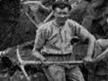
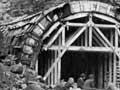
Coal was first mined in western Southland in 1879 at Nightcaps. After those seams were exhausted, neighbouring Ōhai was mined. Nightcaps and Ōhai became mining towns, with strong labour traditions. Since 2009 the only operating mine in this area has been an opencast one at Nightcaps.
In the eastern Southland lignite field the Mataura mine supplied the local paper mill from 1951, but closed with the mill in 2000. In the early 2000s, mines still operated at nearby New Vale and Goodwin.
Transport routes since the Second World War
In 1930, when railway traffic peaked in Southland, there were 586 kilometres of track. Improved roads and more modern trucks and buses then tipped the balance from rail to road freight.
Between 1959 and 1971 more branch lines closed. The Southerner passenger express train from Christchurch to Invercargill, which began in 1948, last ran in 2002.
In the 2010s there were 219 kilometres of railway track in Southland – the South Island main trunk line; Invercargill to Bluff; and Invercargill to Ōhai to transport coal.
From Invercargill to the ice
From 1958 to 1968 the US navy flew regularly between Invercargill and McMurdo Sound. These Antarctic flights attracted large crowds to watch the spectacular night take-offs, which used flame-throwing bottles to get airborne. Some hoped that Invercargill would become the jumping-off point for tourists to Antarctica, but it never happened.
In 1888, Henry Homer had discovered a saddle leading from the Hollyford River to Milford Sound. Work on the Homer Tunnel, to provide a road route to Milford Sound, started in 1935 but was suspended during the Second World War. The tunnel opened for traffic in 1953.
The Southern Scenic Highway runs from Balclutha in Otago to Te Anau, taking in the Catlins district, the Southland coast, and the Waiau Valley.
Air travel
Invercargill airport was built on land which had been reclaimed from the New River estuary between 1919 and 1940. Commercial flights began in 1948.