


Compared with most other regions of New Zealand, Southland has a harsh climate.
Spring and summer
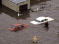
Spring snow-melt or heavy rain in the back country can cause flooding on the plains. On 26 and 27 January 1984, heavy rain on the plains combined with those factors to produce Southland’s worst flood. It caused the evacuation of nearly 4,000 people and cost $50 million in repairs.
Summers are warm, not hot. Invercargill’s mean daily maximum in January is 18.7°C, compared with 22.7°C in Christchurch and 23.1°C in Auckland. However, the long summer twilights make up for the cooler temperatures.
Looking on the sunny side
A promotional book of the 1920s painted the chilly south in glowing terms: ‘Nearer the equator than the south coast of England, [with a] climate mild and equable but bracing, that makes one feel it good to live … fogs are infrequent.’ 1
Winter
Winters are severe by New Zealand standards. The mean maximum temperature in Invercargill in July is 9.5°C, compared with 11.3°C in Christchurch and 14.7°C in Auckland.
Invercargill’s coldest temperature, -9°C, was recorded on 4 July 1996. Southland’s lowest recorded temperature is -18°C, at Glenaray Station near Waikaia, in the same month.
Frosts are frequent inland during winter – Gore averages 114 each year, nearly one day in three. In coastal regions they are less common (Invercargill averages 94) and less severe, but everywhere pastures are closed off and stock are fed on fodder crops such as swedes and turnips.
Snow falls to low levels on the hills. A deep snow that fell over northern Southland in July 1939 took six weeks to clear. Persisting snow is uncommon at sea level.
Sun, wind and rain
Invercargill has an average of 1,682 sunshine hours each year, compared with 2,003 in Auckland, 2,110 in Wellington, 2,142 in Christchurch and 1,684 in Dunedin.
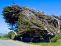
With an average of 98 windy days per year, Invercargill is New Zealand’s second windiest city, after Wellington. Gusts of 143 kilometres an hour struck on 9 June 1993 and 16 May 1994, and a storm on the night of 7 November 1997 caused major damage.
Rainfall averages over 1,000 millimetres annually near the coast, but less than 1,000 millimetres in inland areas.
Rainbows are frequent in Southland. Being closest to the South Pole, Southlanders see more of the aurora australis (southern lights) than other New Zealanders. Several are seen during most months from the southern coast.
Fiordland
Fiordland has the highest rainfall in New Zealand, averaging 6,700 millimetres per year. In 1940, 9,197 millimetres was recorded at Homer Tunnel. Deep Cove in Doubtful Sound, the wettest place in Fiordland, has an annual average of 8,750 millimetres.