

East to Gorge Road
The settlements of Tisbury, Waimatua, Timpanys, Mokotua, Kāpuka, Ashers and Gorge Road are on the road east from Invercargill. Ōteramika and Waituna are north of the road; Kāpuka South is south of it.
The first European settlers established sheep and dairy farms in these districts. Flax milling began in the 1900s and continued until the 1970s.
Townships have now largely disappeared. Many farms have either merged or been split into four-hectare lots for Invercargill workers. Five primary schools were closed in 1969, and pupils are bussed to Gorge Road School, which had a roll of just 52 in 2015.
North-east on State Highway 1
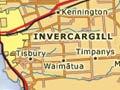
Kennington (8 km north-east of Invercargill) has a variety of industries including a wood-veneer plant, sawmill and venison-processing factory
Woodlands (18 km north-east) was named after William de Gouge Wood who settled there in 1858. It is the site of an agricultural research station, and had a 2013 population of 261.
Dacre (25 km north-east) is the site of AM radio transmitters for the radio stations 4YZ, Newstalk ZB and the Radio Sport Network. The two-teacher Dacre School celebrated its centenary in 1999.
North on State Highway 6
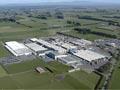
Lorneville (10 km north of Invercargill at the junction with State Highways 98 and 99) was known as Wallace Junction until 1930. The Alliance Group freezing works there is one of the largest in the country.
Makarewa (15 km north) was an early farming settlement. The Invercargill–Makarewa railway, opened in 1864, was the country’s first passenger service. The freezing works, opened in 1912, still operates. In Māori, ‘maka’ means fish hook, and ‘rewa’ means to float. The story goes that a party fishing for eels in the river found their hook swept to the surface in a storm.
Wallacetown
Wallacetown lies 15 km north-west of Invercargill, with a 2013 population of 663. The Underwood Milk Preserving Works opened there in 1892. The Nestlé organisation took it over in 1938, and it became best known for making Highlander Sweetened Condensed Milk, before production was transferred to Auckland in 1964. Many Wallacetown residents work in Invercargill.
West Plains
Lying 10 km from Invercargill, West Plains comprises mostly farmlets running a variety of stock – sheep, deer, horses, ostriches and llamas.
A flying first
Invercargill engineer Herbert Pither claimed to have achieved Southland's – and New Zealand's – first powered flight in his home-built plane, flying for a mile (1.6 km) along Ōreti Beach on 5 July 1910.
West
Ōtatara, 4 km west of Invercargill, just past the city’s airport, has a hall, school and reserve. Nearby is the Teretonga international car-racing circuit. Just south and west of Teretonga lies Sandy Point. Surrounded by bush walks and wetlands, it is a centre for rowing, sailing and boating.
Ōreti Beach (8 km west) faces out to Foveaux Strait. For decades, car and motorcycle races were held along its 13 km of firm sands (it was the home base for legendary Invercargill motorcycle racer Burt Munro). Toheroa shellfish were dug up by thousands of locals in a short season, until declining numbers saw almost all harvesting end in 1981.The dunes are a favourite training ground for runners.