
A remote and rugged region
Most of Fiordland (nearly 1 million hectares) was made a scenic reserve in 1904 and a national park in 1952. The Hollyford valley, formerly farmed, was added to the park in the 1960s, and the Waitutu forest in 1998.
Much of Fiordland consists of crystalline rocks, including granite. Some of New Zealand’s oldest rocks are found there. Hard and resistant, they retain their form in the face of high rainfall. The area’s high-sided valleys, waterfalls and fiords were gouged by glaciers between 75,000 and 15,000 years ago.
Fiordland’s sounds
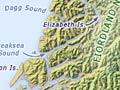
Long-fingered fiords – mostly called ‘sounds’ – reach into the ranges from the coast. North to south they are Milford, Sutherland, Bligh, George, Caswell, Charles, Nancy, Thompson, Doubtful, Dagg, Breaksea and Dusky.
Two inlets – Chalky and Preservation – lead into Cunaris Sound and Long Sound respectively. Ten marine reserves are found along the coast, from Milford Sound (Piopiotahi) to Preservation Inlet (Rakituma).
Sounds like a fiord
The coastal inlets of Fiordland are each named ‘sounds’ (such as Doubtful Sound), but are collectively known as ‘fiords’. ‘Sound’ was used when the waters were charted by Captain John Stokes of the British navy ship Acheron in the early 1850s. The word comes from ‘sund’, Old Norse for ‘swimming’ or ‘strait’. ‘Fiord’ is from the Norwegian ‘fjord’, and relates to the verb ‘to ford’. It was first used in New Zealand in the 1860s – perhaps because Norway’s fjords were popular with British travellers at that time.
Doubtful Sound
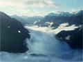
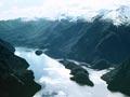
One of the most extensive sounds on Fiordland’s coast, Doubtful Sound (Patea) has several spectacular waterfalls and cataracts. The water that drives the Manapōuri power station is discharged into Deep Cove, at the head of the sound.
British navigator James Cook saw the entrance to the sound on his first voyage in 1770, and named it Doubtful Harbour. Felipe Bauzá y Cañas, a cartographer with the explorer Alessandro Malaspina, investigated the sound in 1793, and sealers visited in the early 1800s.
Dusky Sound
Dusky Sound (Tamatea) is the largest in Fiordland. The English explorer James Cook and his crew spent six and a half weeks there in 1773. Other explorers followed, and sealers who were left at the sound in 1792 were the first European residents of New Zealand.
Sealers and whalers were active through the early 1800s. They hunted seals almost to extinction, and from the 1840s the area was deserted.
Resolution Island
Resolution Island (Tau Moana) was named after the ship of British navigator James Cook on his second voyage to New Zealand. The fifth-largest island in New Zealand, it was the site of the country’s first bird sanctuary in 1894. However, it did not succeed, as it was not far enough from the mainland to remain free from predators.
Preservation Inlet
The Ngāti Māmoe people lived in Preservation Inlet (Rakituma), having fled from tribal warfare in Otago. But in the later 1700s the settlement was obliterated by Ngāi Tahu.
As at Dusky Sound, European whalers and sealers were active in the early 1800s, and a whaling station was established in 1829. A failed attempt at a settlement was made in the 1890s – neither gold mining nor fishing thrived.
Lost and found
People have speculated that some Ngāti Māmoe took refuge in Fiordland in the late 18th century, and their descendants were still there. James Cowan, writing in 1930, thought there was more chance of finding a vanished bird than vanished people: ‘[B]y all means let [a] search party get busy this summer. Though they are not likely to discover the bush tribe, they are certain to find a lot of other items of scientific interest, mayhap that rara avis, the takahea, the notornis like a blue turkey. My own private theory concerning those Ngati-Mamoe is that they were all bitten to death long ago by the sandflies and mosquitoes.’ 1 No lost tribe was ever located, but takahē were found just 18 years later and the sandflies are still biting.
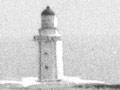
Puysegur Point
Puysegur Point lighthouse was built in 1879 on this most south-westerly point of the South Island. The isolated lighthouse families were served by occasional boats and amphibian aircraft. The lighthouse has been automated since 1989.
Waitutu
Two timber mills opened in 1918 at Port Craig, on the west side of Te Waewae Bay, to log Waitutu Forest. However, both closed in 1928 because of falling prices, and never re-opened.
A 48,000-hectare forest was added to Fiordland National Park in 1998. The adjacent 2,171-hectare block of the Waitutu Incorporation is managed as part of the national park.
The coastal Waitutu Track crosses the Percy Burn viaduct, which is 36 m high and 125 m long. It is one of three such viaducts, and was built from timber in the 1920s to support a logging tramway. The Hump Ridge Track, a route between Port Craig and Lake Hauroko originally used by Māori seeking pounamu (greenstone), was opened by Prime Minister Helen Clark on 3 November 2001.