Winton
2013 population: 2,211
Southland’s third largest centre, Winton is 32 km north of Invercargill. It is named after Tom Winton, a stockman who found lost animals grazing there in 1862. He then camped with his stock by a stream which was named Winton’s Creek.
The district thrived with the development of sheep and fat-lamb farms in the early 1900s. Later, dairy farming became the staple economy, although the town has also seen sawmills, and flax and linen-flax industries.
Not a baby minder
Winton’s most infamous resident was Minnie Dean. She ran a ‘baby farming’ business from the late 1880s, placing babies, mostly illegitimate, in foster homes. Dean was convicted of and hanged for the murder of one of the infants in her care.
Today Winton thrives as an agricultural service town and stop-off for travellers on the Invercargill–Queenstown highway. Its population is not declining, partly because farmers retire there, attracted by a climate that is warmer, drier and calmer than Invercargill or Southland’s coastal districts.
Browns
Eighty years ago Browns, 8 km east of Winton, had two sawmills, a lime works, brickworks and tile works, all using local deposits. Only the lime works survives, but the township still has the usual rural services.
Hedgehope
Further east towards Gore, Hedgehope was originally noted for its sawmills, flax mills, coal deposits and dairy factory. Today, milling the forestry plantation at nearby Pebbly Hills vies with dairy and sheep farming in keeping its economy buoyant.
Limehills
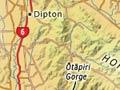
Limehills, 10 km north of Winton, is named for the nearby limestone summit that was quarried and processed. It is a centre for farms and some lifestyle blocks, and has a 150-pupil school and a solar-heated swimming pool. The scenic Ōtāpiri Gorge, 10 km to the east, is on a back road through the Hokonui Hills between Gore and Winton.
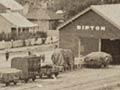
Dipton
Situated 28 km north of Winton, Dipton straddles the Ōreti River. One of the earliest European settlements in Southland, at one time it had two schools, three hotels, three general stores, a bakery, saddlery, butcher, bootmaker, dairy factory and flax mill. The Taringatura Hills (highest point 666 m) lie west of the township and are now mostly in pasture.
Drummond
Drummond, 19 km west of Winton, was formed in 1881 and named after either a local surveyor or William Francis Drummond Jervois, governor of New Zealand from 1882 to 1889.
The township grew after 1893, when the Gladfield Estate was broken into smaller lots. Settlers drained swamps, farmed sheep, and grew oats, wheat, linseed and grasses.
Today Drummond is a typical rural Southland settlement with school, church, store, tavern, garage, rural businesses and community groups – and a striking memorial avenue of trees.
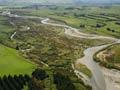
Ōreti River
The 169-km Ōreti River forms at a confluence of streams in the Eyre and Thomson mountains south of Lake Wakatipu. The Ōreti flows east to Lumsden and then south again through central Southland, reaching the sea through the New River estuary at Invercargill. Rainbow and brown trout are caught throughout its length. The Ōreti is the only Southland river that is braided in parts.