
Ōtautau
2013 population: 672
Ōtautau (tautau means a style of greenstone pendant) is 50 km north-west of Invercargill, in the foothills of the Longwood Range.
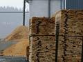
Ōtautau began as a wagon stop on the route between Riverton and Wakatipu. It was the administrative hub of Wallace county (western Southland) for nearly a century. Sawmills processed timber from the nearby Longwood Range, and the township has long served the local farms. The saleyards once handled tens of thousands of sheep annually, but were closed in the 1990s.
Nightcaps
2013 population: 294
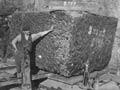
Lying 82 km north-west of Invercargill, Nightcaps unfurls along the foothills that mark the north-western perimeter of the Southland Plains. The settlement developed from 1880 to exploit the massive coal field – a wide band running across Northern Southland.
Nightcaps was a tightly knit ‘company town’ with a strong miners’ union. The Nightcaps Coal Company built its own railway and produced some 1.8 million tonnes of coal, mostly low-grade lignite (or ‘brown coal’), from underground mines. It operated for over 40 years before the mines were exhausted and miners shifted to nearby Ōhai. In the 2010s some opencast mining is carried out.
Ōhai
2013 population: 303
Settlement 8 km north-west of Nightcaps. Ōhai developed in the 1920s as a coal-mining settlement, replacing Nightcaps. Many of the immigrant miners were ‘Geordies’, from north-east England. Underground mining was replaced by opencast mining in 2003, and mining was cut back further after the loss of a major contract from 2008.
A tale of two mines
From 2003 Solid Energy’s opencast mine at Ōhai had a contract to supply coal to Fonterrra’s Clandeboye dairy plant, near Timaru, South Canterbury. But in September 2008 the contract went to Eastern Corporation’s Tākitimu mine at nearby Nightcaps. Mining was to cease at Ōhai in June 2009, but continue at Nightcaps for at least the two years of the contract.
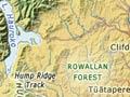
Tūātapere
2013 population: 558
Tūātapere lies 87 km north-west of Invercargill and 9 km inland from Te Waewae Bay. It started as a sawmilling centre in the 1880s. Through the 1920s and 1930s, seven mills worked the timber from both the Longwood Range in the east and the Rowallan Forest to the west.
Two sawmills still operate, but sheep, deer, dairying and potato-growing are more important. The town is also a southern gateway to Fiordland National Park, and to the recently developed Hump Ridge and Waitutu tracks. It claims to be New Zealand’s ‘sausage capital’. State Highway 99 ends at Tūātapere.
North of Tūātapere
The western sector of the southern scenic highway follows the Waiau valley north to Te Anau. The Waiau River drains Lakes Te Anau and Manapōuri, flowing from Manapōuri south to Te Waewae Bay. Salmon as well as trout are caught in the Waiau and its tributaries. Since the commissioning of the Manapōuri hydroelectric scheme, most of the Waiau's former flow has been diverted through the West Arm power station into Doubtful Souind.
Pukemāori
Pukemāori (11 km north-east of Tūātapere) serves local farms and is home to a sizable transport company. Nearby Ōrawia first developed when surrounding land was broken up for closer settlement after 1895.
Clifden
Clifden (14 km north of Tūātapere) is best known for its long suspension bridge, built in 1899 to open up land for settlement west of the Waiau River. Limestone caves and Māori rock drawings are local features. Gentians have been sold in Japan and other northern hemisphere markets from a local property.
Blackmount
Blackmount (28 km north of Tūātapere) was a sawmilling centre. Blackmount School closed in 2014. It lies at the foot of the Tākitimu Mountains (highest point 1,634 m), which are still mostly forested.