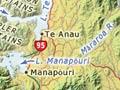
Lakes formed by glaciation mark Fiordland’s eastern boundary, just as sounds (fiords), open to the ocean, mark its west. The lakes are effectively freshwater fiords. From north to south they are Te Anau, Manapōuri, Monowai, Hauroko and Poteriteri.
Lake Te Anau
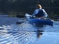
Lake Te Anau (348 sq km) is New Zealand’s second largest lake after Taupō (606 sq km). It is 212 m above sea level, 61 km long and 276 m at its deepest point. Its three fiords – South, Middle and North – separate the Kepler, Murchison, Stuart and Franklin mountains.
The eastern shore of the lake abuts the Southland Plains. The western shoreline gets 1,700 mm of rain each year, the east around 1,100 mm. Glow-worm caves lie on the west side, between the middle and south fiords. The lake yields both trout and land-locked salmon.
Te Anau town
2013 population: 1,911
The settlement was first surveyed in 1893, shortly after the Milford Track opened. But a town only developed after the opening of the Homer Tunnel and road route to Milford in 1953.
Māraroa River
The Māraroa, the longest tributary of the Waiau, rises in the mountains between Lake Te Anau and Lake Wakatipu. It joins the Waiau a few kilometres downstream from Lake Manapōuri.
The two Mavora lakes on the river are popular sites for camping and boating. In 2004 the Māraroa was the first river in New Zealand found to be infected with the alga didymo, which greatly restricted fishing. The Waiau is now also infected.
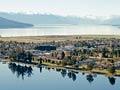
Lake Manapōuri
Its banks dense with beech forest, its waters scattered with islands and its horizon dominated by the Kepler Mountains, Lake Manapōuri has long been regarded as New Zealand’s most beautiful lake. It is 143 sq km, 178 m above sea level, with a maximum depth of 444 m.
It was known to Māori as Moturau, and its present-day name appears to have been the result of a surveyor’s error.
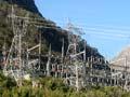
Hydroelectric power station
The Manapōuri hydroelectric power station, New Zealand’s largest, was built between 1963 and 1971. Plans to raise the level of the lake for power generation led to nationwide protests from 1969 to 1972. To generate power, water is diverted down vertical penstocks at the west arm of the lake into a cathedral-like powerhouse 213 m below ground. Here, seven huge turbines each drive a 100,000-kW generator. The water is discharged along a 10-km tailrace tunnel into Deep Cove in Doubtful Sound.
Much of the power is transmitted 160 km to supply the aluminium smelter at Tīwai Point, near Bluff. A second tailrace tunnel was added in 2002.
Sixteen men were killed underground and during construction of the road over Wilmot Pass, built to link the two ends of the tunnel. They are commemorated on a plaque in the power station.
Township
2013 population: 228
The township of Manapōuri is at the south-east corner of the lake. A popular excursion involves a boat trip to the west arm of the lake, a descent to the powerhouse, a bus ride over Wilmot Pass to Deep Cove and a boat trip up Doubtful Sound to the open sea.
Lake Monowai
Boomerang-shaped Lake Monowai was raised 2 m in 1925 to provide more water flow for a power station, which today supplies about 5% of Southland’s electricity. As a result, dead trees line the lake’s banks, marring the landscape and making shore fishing difficult.
Lake Hauroko
South-west of Lake Monowai lies Lake Hauroko, which at 462 m is the deepest lake in New Zealand and the 16th deepest in the world. A Māori burial cave, with remains dating from around 350 years ago, is on Mary Island. The lake is the starting point for a 10-day tramp to Doubtful Sound.
Lakes Monowai and Hauroko are renowned for brown trout and rainbow trout fishing.