Bluff
2013 population: 1,794
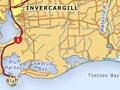
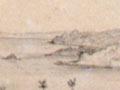
Bluff (27 km south of Invercargill) is New Zealand’s southernmost town and Southland’s port. When sailors on the brig Perseverance arrived in the harbour in 1813, they found a Ngāi Tahu settlement on the seaward side of 265-metre Bluff Hill (Motupōhue).
Flax-processing ventures failed, but in 1824 James Spencer (Timi Katoa or ‘Jimmy the Strong’) set up a trading post. In 1836 Captain William Stirling started a whaling station for pioneer merchant Johnny Jones. A town, originally named Campbelltown, was surveyed in 1856 and became a customs port; a freight and passenger service to Melbourne lasted for 60 years. The Bluff Harbour Board was formed in 1877, and a borough council in 1878. In 1917 the town was renamed Bluff – which is what locals had always called it.
A busy port town
Bluff thrived on its productive hinterland. It had two freezing works until 1925. A new island harbour equipped with automatic meat loaders opened in 1960, more than doubling the port’s capacity. The Tīwai Point aluminium smelter began production in 1971 and has nearly 1000 employees.
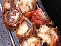
Ocean Beach freezing works closed in 1991, and the parasite Bonomia devastated the harvest of Foveaux Strait oysters from 1986 to the mid-1990s. But Bluff remains home to a fishing fleet which harvests rock lobster and blue cod, and dredges for oysters. There are more fish and shellfish landed at Bluff than at any other New Zealand port. Many of the locals in the fishing industry work in or out of Bluff.
Today the town is best known for the Bluff Oyster and Food festival held every May – a celebration of the nationally-loved delicacy which includes oyster-opening and -eating competitions.
Te Rau Aroha marae, of the Awarua Rūnanga of the Ngāi Tahu iwi, is located in Bluff.
Pāua outage
Bluff couple Fred and Myrtle Flutey created a tourist attraction by covering their house with polished pāua shells and opening it to the public from 1963. Later, after the couple’s deaths, mystery surrounded the destination of the collection when the house was stripped of its 1,170 shells, which were shipped off on a removal truck at night in February 2007. The collection went on display at Canterbury Museum in July 2008, including a re-creation of the Fluteys’ shell-adorned lounge.
Awarua wetlands
The Awarua wetlands comprise nearly 18,000 hectares, with estuarine areas, swamps, forest, tussock land and sand dunes in blocks of land between the New River estuary and Toetoes Bay. The area is home to migratory birds from the northern hemisphere, and birds native to New Zealand.
The wetlands include the Waituna scientific reserve, 3,500 hectares of peat land fronting onto the Waituna Lagoon. In 1976 it was designated a wetland of international importance.
Fortrose
The small, windswept settlement of Fortrose sits near a lagoon at the mouth of the Mataura River on Toetoes Bay, in Southland's south-east.
The site of an early Māori settlement and a whaling station for a couple of years in the 1830s, it thrived as a port until the railway from Invercargill reached nearby Waimāhaka in 1899, making it practical to ship goods through the larger port at Bluff. Today a few houses and cribs (holiday homes) remain, along with a community hall, cafe and cemetery.
Waimāhaka, 10 km north of Fortrose, began as a flax-milling centre in the 1890s. Waimāhaka homestead is a substantial neo-Georgian house built in 1929.
Tokanui
Tokanui (11 km east of Fortrose) began in the 1880s on the back of timber, flax milling and dairying. Today it is a farm service township. The four-teacher primary school, established in 1888, draws children from a wide catchment, having absorbed Fortrose, Ōtara and Quarry Hills schools in 1993.
Waikawa
The farming area of Waikawa is 15 km south-east of Tokanui, on the estuary of the Waikawa River. Waikawa is close to Slope Point, the southernmost point in the South Island. There was a whaling station between 1838 and 1843, after which the settlement became a port for timber, flax and farm produce.
Today, as well as sheep and cattle farming, it offers fishing and dolphin tours. The Curio Bay Jurassic-age fossil forest is nearby, as is Niagara, jokingly named for its modest waterfall. Between Waikawa and Chaslands, the Southern Scenic Highway crosses the Otago–Southland border and enters the heart of the Catlins district.