
Caversham
Caversham is the oldest of the southern suburbs. On the approach to it from the city is Carisbrook, the home of Otago rugby since the early 20th century. The Southern Cemetery and the Oval, a cricket ground, mark the southern end of the town belt. Early Otago leaders Thomas Burns and William Cargill are both buried in the cemetery.
For 30 years from the late 1970s the University of Otago history department carried out in-depth research on late 19th and early 20th-century Caversham and its neighbouring suburbs.
South Dunedin
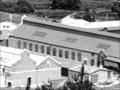
The commercial axis of South Dunedin lies along King Edward Street. The suburb is dominated by the Hillside rail workshops, later Hillside Engineering Group. The workshops were sold back to the government, along with the rest of Toll Holdings NZ’s rail operations, in 2008. They were closed in 2012.
St Kilda and St Clair
King Edward Street becomes Prince Albert Road once it reaches St Kilda, home to the Forbury Park raceway, the A & P (agricultural and pastoral) showgrounds and a magnificent surf beach. An 1,100-metre offshore waste-water system has recently been built out from the St Kilda coast.
St Clair beach is a western extension of St Kilda beach, and has salt-water baths. Substantial houses line the streets on the slopes above the coast. St Clair was the site of an early surf lifesaving club; South Coast Boardriders, established in 1966 and one of New Zealand’s strongest surf clubs, is also based at the beach.
Southern hill suburbs
On the hill slopes east of St Kilda are the suburbs of Musselburgh and Tainui. They abut the suburbs at the landward end of Otago Peninsula – Waverley, Vauxhall, Shiel Hill and Andersons Bay.
Extensive state (public) housing was built after the Second World War on the hills west of Caversham, forming the suburbs of Corstorphine and Kew.
Green Island
8 km south-west of the Octagon, in central Dunedin, with a 2013 population of 6,291, the borough of Green Island was historically distinct from the city. It lies in the Kaikorai Valley, and for many years was dominated economically by the Burnside meat-freezing works, which opened in 1883. Until 1989 it retained its own local council, which took in the suburbs of Abbotsford (site of a 1979 landslide which destroyed or damaged 69 homes), Burnside, Concord and Sunnyvale. From the late 1970s the freezing works mostly handled venison. It closed completely in 2008, because of lack of throughput. Other industrial enterprises process or service primary produce – skins, hides, agricultural machinery or fertiliser. The suburb is probably named after tiny Green Island, off the coast.
Waldron’s ville
Waldronville was developed in the 1950s by Bill Waldron, who bought a local farm, subdivided it and built houses. The street names include Vampire, Vulcan, Viscount and Valiant roads, as well as Dakota Place and Delta Drive – all named after aircraft.
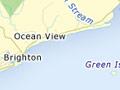
Brighton
A coastal settlement 19 km south-west of central Dunedin, Brighton was expected to grow to rival the British resort town of the same name. It never developed on that scale, but its ‘underdevelopment’ is part of the appeal for residents and visitors. The road to Brighton passes Waldronville and Ocean View.
Saddle Hill
Saddle Hill, with twin summits of 430 m and 473 m, was sighted from sea and named by James Cook in 1770. It is a landmark on Dunedin’s southern skyline.