Wānaka
The town of Wānaka, situated on Roys Bay, in the extreme south-east corner of Lake Wānaka, is 270 km north-west of Dunedin and 70 km north-east of Queenstown, with a 2013 population of 6,471. Wānaka, formerly known as both Roys Bay and Pembroke, has grown rapidly; between 1996 and 2006 the population doubled.
For many years Wānaka was a quiet summer holiday place, although thousands visited for New Year’s Eve celebrations – often rowdy. The skifields which opened from the late 1970s made Wānaka into an all-season tourist resort. The town hosts the annual Festival of Colour, an arts festival held in autumn.
The Anderson Heights industrial zone sits below Mt Iron scenic reserve, which separates Wānaka and Albert Town; nearby Puzzling World is a recreational maze. At Glendhu Bay a luxury golf resort is planned. Mt Aspiring College, established in 1986, is well known for its outdoor education courses.
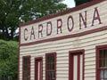
Cardrona
Settlement 25 km up the narrow Cardrona River valley from Wānaka, and the site of a modest gold rush in 1862. The Cardrona hotel dates from 1863 and a district hall from 1879. For many years Cardrona School was the largest in the Wānaka district.
The Cardrona downhill skifield opened in 1977. 13 km east of the Cardrona road, on the Pisa Range, Snow Park and Snow Farm are centres for cross-country skiing.
Crown Range
A mountain range on the west flank of the Cardrona valley. Explorers and runholders William Rees and Nicholas von Tunzelmann followed a route over the range from Lake Wānaka to Lake Wakatipu in 1859. The highest peaks are Cardrona (1,934 m) and Crown Peak (1,729 m). The highway, fully sealed since 2000, crosses a 1,076-m saddle in the range at its southern end, the highest point on a South Island main road. There are spectacular views over the Arrow basin.
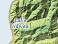
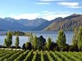
Lake Hāwea and Hāwea Flat
Lake Hāwea is a holiday settlement at the south-west corner of the lake.
Hāwea Flat settlement originated as housing for workers building the Lake Hāwea dam. A grazing district, the Flat now also has a number of vineyards.
Luggate
Settlement and farming district east of Wānaka. The nearby airport is the home of the Warbirds Over Wānaka air show, first mounted by aviation entrepreneur Tim Wallis in 1988 and now a biennial display of wartime aircraft and other features.
Lindis Pass
Pass at an altitude of 971 metres, on State Highway 8 between Central Otago to the south and the Mackenzie Country and North Otago to the north. Lindis Pass provides a break in the ranges that mark the northern edge of the Central Otago schist block, and is on the watershed that separates the Waitaki and Clutha River catchments. The pass was used by Māori and traversed by Otago surveyor John Turnbull Thomson in 1857; he named it for Lindisfarne island in north-east England, his home. Tarras, a locality on the approach to Lindis Pass, is named for a stream in Scotland.