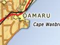

Ōamaru
125 km north of Dunedin and 86 km south of Timaru, Ōamaru enjoys a protected location in the shelter of Cape Wanbrow. It had a population of 13,050 in 2013.
The town was laid out in 1858 by Otago’s provincial surveyor John Turnbull Thomson, who named the streets after British rivers.
Bad taste = good health
Lane’s Emulsion, a tonic made with cod liver oil , was devised by Ōamaru pharmacist Edward Lane and first sold in 1898. It proved so popular that a factory was set up in the town, where the tonic was produced until 1984.
Growth and religion
The boost given by public works, including harbour development, and an export trade in wool and grain from the 1860s, saw the town more than triple its population from 1,657 in 1871 to 5,791 a decade later. By the mid-1880s the town centre was home to an impressive array of buildings made from locally-quarried limestone.
In the first two-thirds of the 20th century nearly half of Ōamaru’s population described themselves as Presbyterian. The district went ‘dry’ in 1906, and stayed that way until 1960 – the last South Island district to resume alcohol sales.
Education
In the early 20th century Ōamaru became noted for education. It was home to two state high schools – Waitaki Boys’ and Waitaki Girls’ – and three Catholic ones – St Kevin’s, Teschemakers and St Thomas’s. Waitaki Boys’ High School gained a national reputation during the rectorships of J. R. Don (from 1896) and Frank Milner, who held the position for nearly 40 years from 1906.
Limited development
Apart from a few years in the 1920s, and in the 1950s and 1960s, the town itself hardly grew after 1881. Its small hinterland – a triangle of farmland, no more than 35 km on each side (the Pacific Ocean, the Waitaki River and the Kakanui Mountains) – limited its development. After the Second World War the port mainly had trans-Tasman and coastal trade.
The modest circumstances of many locals, who might work on the railways or in a foundry, flour mill or shop, is captured in Ōamaru-raised Janet Frame’s novel Owls do cry (1957) and the first volume of her autobiography, To the is-land (1982).
Population
The town’s population reached 12,429 in 1961. It grew modestly in the 1960s but not after that. The port closed in 1974. Many young people left for education and work; the 2013 census recorded 828 10–14-year-olds in the town, but only 561 20–24-year-olds.
Visitor attractions
From the 1980s Ōamaru began to promote its built heritage and other attractions, notably a blue penguin colony at Cape Wanbrow. It is sometimes referred to as the ‘white stone city’, as fine colonial stone buildings line its main streets and port area. The impressive public gardens were laid out in the 1880s. The Forrester Gallery, housed in the former Bank of New South Wales building, has an art collection which focuses on regionally significant works.
Weston
5 km west of Ōamaru in the Waiareka Valley, Weston had a population of 807 in 2013. It is most noted for its limestone quarries, the main source of the renowned Ōamaru building stone. In the early 2000s the Holcim company’s plan to build a cement plant in the valley was vigorously opposed locally.
Pukeuri
9 km north of Ōamaru, Pukeuri had a 2013 population of 210. Its meat-freezing works date from 1914. The works have a labour force of 1,000 during the peak season, and were the largest employer in North Otago in 2008, paying around $30 million in wages annually.
Latitude 45 degrees south – halfway between the equator and the South Pole – is marked on State Highway 1 just north of Pukeuri.