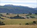
Blue Mountains
Tapuaeuenuku (footprints of the rainbow) was named the Blue Mountains by Walter Mantell in 1851. The mountains are known locally as ‘the Blueys’; the highest peak, Tapanui Hill, is 1,019 metres. In the 2010s plantation forests were owned by Ernslaw One, a Malaysian company, which operates the Blue Mountain Lumber plant at Conical Hill. The Blue Mountains forest conservation area lies along the western flank of the range and is used by deer and pig hunters. Black Gully and Whisky Gully have bush walks.
Tapanui flu
In the early 1980s, Tapanui GP Peter Snow noticed that some of his patients had symptoms that resembled those of farm animals with selenium deficiency. Working with Otago University colleagues, he studied the local outbreak of what came to be known as Tapanui flu, or chronic fatigue syndrome.
Tapanui
Tapanui, which brands itself as ‘the edge of the forest’, had a 2013 population of 726. The principal township of West Otago, it is 71 km north-west of Balclutha, but just 38 km north-east of Gore, in neighbouring Southland, with which it has many links.
A first sawmill started in 1866; Tapanui was laid out in 1868. By the 1920s, forest had largely given way to sheep farms. Nearly all of these have converted to dairying since the early 1990s.
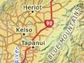
Kelso and Heriot
North-west of Tapanui, Kelso dates from 1865. After floods in 1978 and 1980, when the waters of the Pomahaka River rose 2 and 3 metres respectively, the township was abandoned.
The 1885 Todd cottage at Heriot, west of State Highway 90, was the birthplace of Charles Todd. He founded Todd Motors, which became one of the country’s most successful car companies. The Todd family’s first industrial enterprise was the fellmongery opposite the house, which still stands.
Roxburgh railway
The Milton–Roxburgh railway opened up the section of the Clutha River from Beaumont to the Roxburgh Gorge. The railway closed in 1968.
The 9-km Beaumont Millennium Track runs from Beaumont, where State Highway 8 joins the Clutha River, towards Millers Flat.
Millers Flat
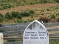
Settlement across the Clutha River from State Highway 8, reached via a five-span bridge. 9 km south are the ‘lonely graves’ where are buried both ‘somebody’s darling’ (an unidentified body found during the gold rush years) and William Rigney. Rigney’s headstone describes him as ‘the man who buried somebody’s darling’ – but by his own account he did not bury the body, but simply erected a mānuka fence and wooden headstone on the grave.
Roxburgh
40 km south of Alexandra, Roxburgh is at the junction of the Teviot and Clutha rivers, and had a 2013 population of 522. Finds of gold on the Teviot in 1862 by Andrew Young and James Woodhouse gave the township its start.
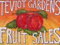
The town takes its name from a Scottish border town, and its streets are also named for border localities. Roxburgh was a major centre of gold dredging at the end of the 19th century. The Ladysmith dredge, named after the South African war siege of the British stronghold of Ladysmith, operated for some years on the east bank of the river. The sluicing channels made by miners were later used for irrigation, allowing orcharding to develop at the start of the 20th century. Some of the apricot yield was canned locally until the early 2000s.
Lake Onslow
22 km east of Roxburgh, at the head of the Teviot River, Lake Onslow is a product of the 1888 damming of the upper Teviot River by the Roxburgh amalgamated mining company. It is named after Lord Onslow, governor of New Zealand from 1889 to 1892. The dam was progressively raised, then rebuilt; the lake is now 830 hectares and has many brown trout.
Fruitlands
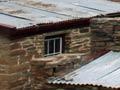
The name of Fruitlands, 15 km south of Alexandra, is a reminder of an unsuccessful fruit-tree planting venture in 1915. It was formerly also known as the Halfway. The stone building of Mitchells Cottage was erected between 1880 and 1904 by Andrew Mitchell, a gold miner and stonemason (a skill he had acquired in his Shetland Island homeland). A memorial at Gorge Creek commemorates miners who died in the great snowfall of 1863.
Old Man Range/Kopuwai
In Māori the range is known as Kopuwai after the ‘ogre’ who once lived there. The Obelisk, or Old Man Rock, 25 metres high and 8.5 metres wide at its base, is prominent on the ridge line. The Flat Top Hill conservation area at the foot of the range conserves a dry land ecosystem.