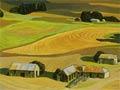
Rural North Otago comprises farming districts around Ōamaru, coastal settlements to its south, and the Otago side of the upper Waitaki valley. Tours from Ōamaru visit historic Burnside homestead, the nearby Elderslie estate’s gardens, and Tōtara Estate, which processed the carcasses for New Zealand's first frozen meat shipment in 1882.
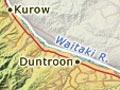
Duntroon
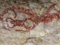
Duntroon is 45 km north-west of Ōamaru, where State Highway 83 meets the Danseys Pass road to Central Otago. Named after the Scottish home town of estate owner Robert Campbell, it had a population of 87 in 2013. Rock outcrops and fossil beds in nearby rolling hills are a distinctive part of the landscape, and there are Māori rock drawings at nearby Takiroa. The 1876 Campbell homestead is a short distance from Ōtekaieke. Ngāpara, on a back road towards Ōamaru, has a flour mill, one of many that operated in the district before milling was centralised.
Kurow
Kurow is in the upper Waitaki River valley, 68 km north-west of Ōamaru. The town is on State Highway 83, at a bridge over the river which connects it with the Hakataramea River valley in South Canterbury. The name is a version of Te Kohurau, meaning many mists. The population ballooned in the 1920s due to the construction of the Waitaki dam, which was completed in 1935. Kurow’s 2013 population was 312. It is now primarily a farm service township.
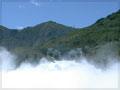
Ōtemātātā
Ōtemātātā is on the Waitaki River between the artificial Lakes Benmore and Aviemore, 95 km north-west of Ōamaru. It was established in 1958 as a construction town for the Benmore and then the Aviemore power stations, and had a population of 4,000 in the mid-1960s. The much-reduced total of under 300 in the 2000s is supplemented in summer by holidaymakers.
Ōmarama
Junction town 119 km north-west of Ōamaru, with a 2013 population of 267. Many thousands of travellers pass through Ōmarama en route from Aoraki/Mt Cook and the Mackenzie Country to Queenstown, Wānaka and Central Otago, via the Lindis Pass. Wind currents in the district provide ideal gliding conditions. The town’s name refers to the moon (marama).
Kakanui
14 km south of Ōamaru on the coast east of State Highway 1, Kakanui had a 2013 population of 372. A port was built in the 1870s and a harbour board was established, but was abolished in 1886 after sea damage wrecked the harbour. Holiday homes were built in the township from the 1920s. There are fine churches at Maheno and Herbert, both a few kilometres inland on State Highway 1.
Hampden
34 km south of Ōamaru, Hampden had a 2013 population of 300. A camping ground was established after the First World War, and tourist-oriented businesses have operated since the 1980s.
Moeraki
Fishing and holiday locality 37 km south of Ōamaru, on a peninsula east of State Highway 1. A coastal whaling station was established in 1836, and a Māori settlement grew up on the hill above. Moeraki was the district’s first port, and a Pākehā township developed along the road and branch rail line which led between the port and the main road and railway. The port lost ground to better-sited Ōamaru, but is still home to fishing vessels. Moeraki is known for the ancient spherical boulders that litter the nearby beach. A millennium walkway, a penguin colony and Katiki lighthouse (built in 1878, and automated since 1975) are popular with visitors.