The principal city of the lower South Island, with an urban population of 112,035 in 2013. Once New Zealand’s largest city, Dunedin remains significant on account of its history, and its status as a centre for university education, and scientific and medical research.
Early years
The town was founded in 1848. Charles Kettle, surveyor for the New Zealand Company, placed the Octagon at its heart, with Moray Place forming an outer octagon of thoroughfares. George and Princes streets – the names of Edinburgh’s principal streets – were the axis, and a town belt reserve separated town and country.
After 10 years the settlement’s population was just 1,712. It was the gold rushes from July 1861 that transformed Dunedin – its population increased to nearly 15,000 by the end of the 1860s, and nearly tripled between then and 1881. In the mid-1860s, and between 1878 and 1881 (but never again), it was New Zealand’s largest urban centre.
The city invested in education, religion and public works. Bell Hill, between the Octagon and the harbour, was demolished to allow expansion. Substantial buildings included Otago Museum (1876–77); the main building of the University of Otago with its clock tower (1878); the council chambers (1878–80); and St Joseph’s Catholic cathedral (1886). Architect Robert Lawson was responsible for some of the most distinctive buildings – First and Knox Presbyterian churches (1873 and 1876), Otago Boys’ High School (1884), and Trinity Methodist Church (1870), since 1978 the home of the Fortune Theatre. Dunedin Public Art Gallery was set up in 1884; it moved into a refurbished building in 1996.
Boom times
In 1900 Dunedin’s capitalists thrived on the back of a gold dredging boom. They traded nationally and internationally. The city’s schools and university were New Zealand’s best. Missionaries from Dunedin ranged as far as China and India, and the city’s vigorous working class was the backbone of the nascent national labour movement. Jewish, Lebanese and Chinese communities gave a distinctive cast to the city’s business and public life.
Banks and other financial institutions clustered along Princes Street, south of the Octagon. Nearby Walker (now Carroll) Street was a poor neighbourhood. The city’s bourgeoisie built substantial residences adjacent to the town belt, most notably the Theomin house Olveston (1906). Cable cars ran to hill suburbs, and trams to ‘the Flat’ (South Dunedin).
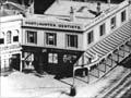
Railway station glories
Dunedin’s railway station was effusively celebrated in a 1970s guidebook: ‘In the concourse, exaltation is everywhere to be seen; the NZR cipher is engraved on scores of windowpanes, woven into ornate scrolls above the ticket windows and incorporated in matching stained-glass windows, each portraying a locomotive approaching at full steam. Sixteen ceramic nymphets look down approvingly at a majestic mosaic floor, whose tiles repeatedly mirror the cipher.‘ 1
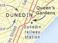
A wave of public building saw the completion of the law courts (1900–2), the main railway station (1904) and St Paul’s Anglican Cathedral (1915). The city cherished its past, developing the Settlers Museum (1898) adjacent to Queens Gardens, and the Hocken Library (1910), based around the book and manuscript collection of local doctor and coroner Thomas Morland Hocken. Electric power was reticulated from the city’s Waipori Falls power station from 1907.
With the end of the gold dredging boom, Dunedin’s hinterland had a mostly pastoral economy; it was the South Island’s leading wool-selling centre. The city gained new enterprises – cinemas and publishers – and the 1925–26 New Zealand and South Seas Exhibition was a powerful vote of confidence. But Dunedin’s 1926 population of 85,000 was not surpassed until the late 1940s (partly because of the 1930s economic depression).
After the Second World War
In the era of post-war growth, partly a product of prosperous farming and the expansion of industry and state activity, new suburbs were built on the hills west and south of the city. Shops and offices were increasingly located north of the Octagon. Mōmona, the new airport, opened in 1962, and the Olympic-size Moana pool opened in November 1964.
However, population growth was modest. Businesses increasingly preferred to be sited close to larger markets, and jobs went with them. Dunedin’s 2013 population was just over 10% more than in 1956 – in that period Auckland’s population had more than tripled.
In the 2010s a number of businesses thrived. They included the very specialised, such as McKinlays footwear, and the more substantial, such as the Cadbury chocolate factory in downtown Dunedin. But many others had closed – notably woollen mills, whiteware assembly plants and freezing works.
The University of Otago had a student roll of over 18,800 in 2013 – more than six times what it was a half-century earlier – and played a dominant role in the city’s economy and its social and intellectual life. Increasing numbers of international students made the city’s population more diverse.
New Zealand’s first Chinese garden opened in July 2008, close to the Otago Settlers Museum and Queens Gardens. The decision to build a covered sports stadium near Logan Park, in the hope of making Dunedin an ‘events’ city, was controversial. The Forsyth Barr stadium was completed in August 2011.