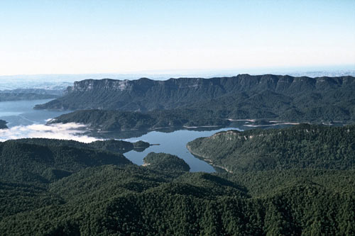
The arms of Lake Waikaremoana are old river valleys, flooded when an enormous landslide blocked the Waikaretāheke River about 2200 years ago. The Panekiri Range, behind the lake, is made of sandstone that was deposited about 10 million years ago, compressed and later uplifted. Conifer–broadleaf forest covers the area around the lake – mainly a mix of northern rātā, rimu and tawa, with silver beech on the ridges.
Te whakamahi i tēnei tūemi
Reference: 10052243
This item has been provided for private study purposes (such as school projects, family and local history research) and any published reproduction (print or electronic) may infringe copyright law. It is the responsibility of the user of any material to obtain clearance from the copyright holder.
Comments
09 April 2011