
Southern Alps
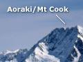
Stretching more than 500 kilometres from Mt Aspiring (Tititea) to the Nelson lakes, the Southern Alps are being raised along the Alpine Fault and many smaller faults to the east. The main divide and the Southern Alps’ highest peaks are near the mountains’ western margin – the top of Aoraki/Mt Cook is less than 35 kilometres from the Tasman Sea.
The mountains are largely greywacke – hard grey sandstone with layers of mudstone, often turned on end. West of the main divide is a thin band of schist – a shiny, layered rock.
A bit off the top
Until 1991, New Zealand’s highest peak, Aoraki/Mt Cook, was 3,764 metres high. Shortly after midnight on 14 December 1991, a large landslide destroyed part of the High Peak, eventually leaving the mountain 40 metres shorter. It is still several hundred metres taller than its closest rival, nearby Mt Tasman.
The Southern Alps are a major barrier to travel. Only a few roads link the east and west coasts, leading along deep gorges and over passes – Arthur’s Pass, Lewis Pass and the Haast Pass.
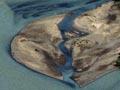
Beech forest once covered much of the Southern Alps. Large tracts remain near the main divide, but much of the eastern mountains was cleared for grazing. Their slopes are largely treeless, with extensive areas of scree. Broad gravel-bed rivers wind along flat valley floors and through interior basins, such as the Castle Hill and Mackenzie basins. Large alluvial fans spread out at the base of mountain valleys.
On the western side, lushly forested mountains rise abruptly from the coastal plains. Rivers cascade down the steep slopes, fed by the high rainfall.
Mountain namesakes
Geologist Julius Haast, who founded the Canterbury Museum, explored the Southern Alps in the 1860s. He named many peaks after British and European scientists – then wrote to introduce himself and tell them about it. He took the chance to build up networks – and the new museum’s collections.
Glaciers and glaciation
New Zealand’s biggest glaciers are clustered about the highest peaks. On the West Coast, Franz Josef and Fox glaciers descend almost to sea level from high-altitude snow basins. East of the divide, the 29-kilometre Tasman Glacier, New Zealand’s largest, flows past the foot of Aoraki/Mt Cook.
Glaciers were much bigger during the ice ages, and shaped much of the Southern Alps. They flowed from the main divide through valleys to the top of the Canterbury Plains and into the Tasman Sea, gouging basins now filled by lakes such as Tekapo, Pūkaki and Ōhau.
Canterbury Plains
Rivers such as the Waimakariri, Rakaia and Rangitātā have left sloping fans of greywacke gravel as they emerge from the mountains, creating the Canterbury Plains. This is New Zealand’s biggest lowland – 180 kilometres long and up to 70 kilometres wide. Over many glacial and interglacial periods, the plains have built up into the sea. They reached the huge basalt island volcanoes of Banks Peninsula only relatively recently, in geological terms.
Christchurch is on the coastal fringe of the Waimakariri River fan, just north of Banks Peninsula. Some suburbs spread up the volcano flanks, but much of the city is built on old river channels, with the river held at bay by stopbanks.
Westland
The narrow belt of lowlands on the West Coast, northward from Jackson Bay, are made of hard, often crystalline rocks. The land is relatively low because it lies on the west side of the Alpine Fault, where there is little uplift. These lowlands are covered with huge ridges of moraine – debris from ice-age glaciers that flowed westward from the mountains to the Tasman Sea.