Described by the Lonely planet guidebook as the world’s biggest film set, New Zealand has diverse landscapes that attract several million tourists each year.
In just one day you can see the sun rise over Christchurch and the Canterbury plains, drive over an alpine pass with towering beech forests, walk on the Franz Josef Glacier, and watch the sun set over the Tasman Sea.
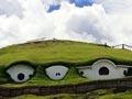
Middle Earth down under
J. R. R. Tolkien’s The lord of the rings trilogy was filmed in New Zealand in 1999–2000 by director Peter Jackson. Many Tolkien fans worldwide now have a vision of his fictional Middle Earth based on New Zealand landscapes.
‘A large land, uplifted high’
In 1642, Dutch explorer Abel Tasman arrived off the South Island’s west coast and saw ‘a large land, uplifted high’. His impression was accurate – New Zealand is mountainous, with a long narrow shape and rugged terrain.
Colliding plates
New Zealand lies on the boundary between the Pacific and Australian tectonic plates. In the north, the Pacific Plate is bulldozing its way under the eastern North Island. This is pushing up a central backbone of mountains and shelves of sedimentary rock. Rivers have cut through these softer rocks, creating the steep, easily-eroded hill country of much of the North Island.
Molten rock welling up from the colliding plates has produced a zone of active volcanoes in the central North Island. The most obvious are the cone-shaped volcanoes that form Ruapehu, Ngāuruhoe and Whakaari (White Island). Large pumice eruptions have left behind depressions (calderas), now filled with lakes, notably Lake Taupō. Near Christchurch and Dunedin ancient volcanoes form hills, and the harbours around which the cities are based.
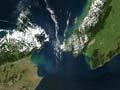
In the South Island, two sections of continent are colliding along this plate boundary – the Alpine Fault. East of the fault, land is being forced upward to produce the remarkably straight rampart of the central Southern Alps, which is visible from space. The uplifted bedrock has become the South Island’s mountainous terrain, with 20 peaks over 3,000 metres high.
Forces changing the landscape
The details of New Zealand’s landscapes have been etched by erosion and weathering from running water, ocean waves and glaciers, as well as by the catastrophic effects of landslides.
Rain
The central mountains force moist winds blowing from the Tasman Sea upward, to form clouds that rain heavily on the western side of the country. Parts of the South Island’s West Coast, deluged by up to 15 metres of rain each year, are some of the wettest places on earth.
Eastern regions get only 10–20% as much rain. Central Otago is the driest part of New Zealand, but is not a true desert, as all areas receive some rain every year.
Glaciers
In the higher Southern Alps much of the precipitation falls as snow, which turns into glacier ice covering over 1,000 square kilometres. Much of the South Island’s landscape was shaped by massive ice-age glaciers.
Life’s a beach
New Zealand has a remarkable amount of coastline – about 18,000 kilometres, the seventh longest of any country. Nowhere is more than 130 kilometres from the sea, so it usually doesn’t take long to get to the beach.
Rivers and coastline
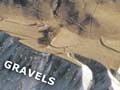
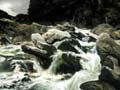
Rivers have carved into the hills and mountains, sometimes forming deep gorges and flights of terraces. Many New Zealand rivers have shallow channels flowing over gravel beds, and move vast amounts of rock debris to the sea.
New Zealand’s dramatic coastline ranges from southern glacier-carved fiords to the sweeping sandy beaches of the far north.