The top of the South Island is a maze of hills and mountains. Split by the Alpine Fault, the rocks are more varied than anywhere else in New Zealand. There is little flat land suitable for agriculture, which led to conflict between European settlers and Māori in the early 1840s.
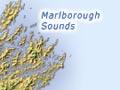
Marlborough Sounds
The South Island’s north-east corner is the Marlborough Sounds. This labyrinth of steep ridges, islands and river-carved valleys has been invaded by the sea, not just by rising sea levels after the last ice age, but because the area is sinking – tilting to the north-east. On the coast’s exposed outer edges, the waves of Cook Strait have cut dramatic cliffs. In the sheltered waterways within the Sounds, the hillsides slope more gently to the water’s edge.
Marlborough mountains and plains
South of the Marlborough Sounds, blocks of land have been raised and tilted along major faults. These form a series of ranges, including the Seaward and Inland Kaikōuras, and the Richmond Range.
Major rivers, such as the Wairau, Awatere and Clarence, flow through the long, straight valleys at the foot of each range. They carry gravels, which have formed large alluvial plains.
The Wairau plain is the largest flat area in the northern South Island. Grapes grow well on the free-draining gravels, and much farmland is now being turned into vineyards.
Moutere depression
The Moutere depression is a north–south belt of gravel and sand, more easily eroded than the ranges around it. The hill country is too steep for farming, and has mostly been cleared and planted in Pinus radiata. Near the coast is a relatively small area of flat land, the Waimea plains, which is intensively farmed.
Flat-tops
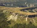
Most mountains are pointed and spiky, but the north-west South Island has some unusual flat-topped summits. Originally under the sea, the ranges have been uplifted over the last million years, but did not erode into peaks because of their very hard, flat rock layers – limestone in the Matiri mountains, and sandstone in the Denniston–Stockton plateau.
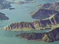
North-west Nelson
Rugged and isolated, this corner of the South Island lies on bedrock of various ages and types, leading to diverse landforms.
The coastal Abel Tasman National Park has granite headlands and golden beaches, very different from New Zealand’s many grey-sand beaches. On the western edge of the park, Tākaka Hill and Canaan Downs are made of marble bedrock. This has dissolved to produce a network of deep caves, topped by a landscape of fluted rock, sinkholes, and pits such as the 176-metre-deep Harwoods Hole.
The remote Tasman Mountains largely lack road access, and are mostly part of Kahurangi National Park. A 30-kilometre-long expanse of sand, Farewell Spit, extends eastward from the park’s northern tip. The Heaphy Track provides an easy route for walkers from Golden Bay to the West Coast. In contrast, the Tasman Wilderness Area has deliberately been left without tracks and huts.
Buller River
The Buller River follows a tortuous 180-kilometre route from Lake Rotoiti westwards to the sea. It cuts through three granite mountain ranges, forming spectacular steep gorges. A road has been cut along the river, so the route that took early explorers several weeks now takes only several hours.
Westport is a port and mining town at the river’s mouth. The surrounding area is simply known as Buller. The Paparoa Range towers over the coastal area, forming part of Paparoa National Park.