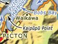
Picton
Marlborough’s second-largest town, with a 2013 population of 4,236, Picton has an impressive setting in upper Queen Charlotte Sound, in the inlet known as Picton Harbour. The harbour is flanked by two headlands, Wedge Point and the Snout, and comprises two inlets, Picton Harbour proper and Shakespeare Bay.
Provincial streets
Many of Picton’s first streets were named after New Zealand provinces – as well as, more characteristically, for English counties. The town centre has Taranaki, Auckland, Wellington and Otago streets and a Nelson Square alongside Devon, Oxford, York, Kent and Durham streets.
History
The town is on the site of the Te Āti Awa settlement of Waitohi, which was established by migrants from Taranaki in 1828. In March 1850 the site was bought from Te Āti Awa, who moved to neighbouring Waikawa Bay, still a Māori centre in the 2010s. A town was surveyed but most section buyers were speculative, anticipating a road between Waitohi and the Wairau.
In 1859 the province of Marlborough was established. Governor Thomas Gore Browne renamed the town Picton, and named Mabel Island in Picton Harbour after his daughter. Settler Thomas Allport farmed the island named after him for some years.
Long-winded
In 1865 the Marlborough provincial council debated holding its sessions in Blenheim, not Picton. Determined to keep the council in Picton, councillor Arthur Beauchamp, grandfather of Katherine Mansfield, engaged in an unsuccessful stonewall by speaking for 10 hours and 40 minutes, concluding by saying, ‘With these preliminary remarks I will now proceed to speak to the matter under discussion.’1 At the end he collapsed and had to be carried from the chamber.
The provincial council was established at Picton. Many of the runholders owned town sections and saw profits ahead. But commercial interests in Blenheim, which was thriving on account of its central location, resulted in the council shifting there in 1865.
The railway connected Picton and Blenheim in 1875; Picton gained a borough (town) council in 1876, but it was Blenheim which grew – with 3,222 residents in 1900 compared to Picton’s 875.
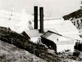
Picton’s population increased to 1,361 in 1911, probably on account of the freezing works, which opened in 1900 (and remained the town’s biggest employer until its closure in 1983). But only in 1956 did the population pass 2,000.
Picton’s situation was revolutionised with the introduction of the roll-on, roll-off Cook Strait ferry in 1962. It became a ‘station’ on both the road and rail main trunk routes. This had less effect on the permanent population (2,315 in 1961, 3,220 in 1981) than on the transient population and on employment. On census night 2013 Picton housed 4,752 people, but had 4,053 residents. Over 40% of Picton’s workforce worked in accommodation, transport, rental, hiring and real estate, compared with 12.7% nationally.
In the 1990s the berthing area was reconstructed to host larger vessels and to allow logs to be shipped. Waimahara wharf in Shakespeare Bay was opened in 2000. Kaipūpū Point on the seaward side of the wharf is a ‘mainland island’ for conservation of native species, protected by a predator-proof fence.
The railway station building, designed by George Troup, dates from 1914. The Picton waterfront was redeveloped between 2009 and 2011.
Picton is the principal headquarters for the Sounds, with an array of vessels ferrying visitors and locals to bays and accommodation. It is popular with retired people – in 2013, 26.4% of the population was over 65, compared with 14.3% nationally.
Waikawa
Suburban settlement 5 km from downtown Picton at the end of Waikawa Road and the head of Waikawa Bay.
Arapaoa is the name of the meeting house on the Waikawa marae. Waikawa is home to Picton’s secondary school, Queen Charlotte College, and a large marina.
Waikawa valley and bay are separated from Picton by a ridge that ends in the Snout, reached by a 90-minute walking track. The ridge and promontory form the Victoria Domain, with Bobs Bay a popular beach.
Grove Arm
Stretch of water at the head of Queen Charlotte Sound. The winding Queen Charlotte Drive passes through settlements at Ngākuta Bay and Momorangi Bay to the Grove settlement itself, 18 km west of Picton.
Anakiwa, on the north side of the Arm, was farmed by Cradock and Harriet Beauchamp, great-uncle and -aunt of author Katherine Mansfield, from the 1860s until the 1900s. Later a lodge for holidaymakers, the homestead became the centre for the New Zealand Outward Bound Trust in 1962.
Koromiko
Farming locality in the hills, 9 km south of Picton on State Highway 1. Koromiko is the site of Picton’s airport, with a church in continuous use since 1871 and a school which first opened in 1876. A cheese factory operated from 1919 until 1980. The Collins Memorial Deer Park opened in 1968.
Para
Once a large kahikatea and tōtara swamp. In colonial times most of the forest was cut and rafted down to Tuamarina. The remaining swamp is popular with duck hunters.