Tuamarina
Locality 10 km north of Blenheim on the Tuamarina River, a tributary of the Wairau, where it leaves the hills. In June 1843, 22 Europeans and at least four Māori were killed at Tuamarina in a confrontation over land ownership. The conflict, which came to be known as the Wairau affray, was a shock to European settlers across the country. Memorials at the conflict site and in the cemetery remember the settlers who died.
Autopography
The poet Eileen Duggan was born at Tuamarina in 1894. She went to primary school in Tuamarina and high school in Blenheim. In 1949, when contributing to a school history, she wrote that 'to be asked to write of Tua Marina is almost like a request to write on self'.1
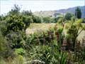
Commercial dairy farming started in the 1890s. In the 20th century there was an award-winning cheese factory, but it closed after a fire in 2004. In the 2010s Tuamarina had a feeder dairy plant for the Fonterra dairy company.
Spring Creek
Township 6 km north of Blenheim, on State Highway 1 between Blenheim and Picton, earlier known as Marlboroughtown. The creek is fed from an underground spring. Henry Redwood Junior imported Marlborough’s first steam plough for use on his land at Spring Creek, where he had a flour mill. Flax was also harvested in the area.
Grovetown
Locality 4 km north of Blenheim on State Highway 1, named because of former stands of native bush. An earlier name was ‘Big Bush’. Grovetown is the site of a Rangitāne marae and meeting house, Tua Mātene. A project is under way to restore the Grovetown lagoon, formerly a bend in the Wairau River.
Marshlands
Locality on the Wairau floodplain, 11 km north-east of Blenheim and immediately south of the Wairau River diversion channel. The name reflects the once swampy nature of the terrain. The Chaytor family have owned land at Marshlands since 1880. Edward Chaytor was a military commander of New Zealand forces in Egypt and Palestine in the First World War.
Wairau Pā
Locality 11 km north-east of Blenheim, on the east bank of the Wairau River, reached from State Highway 1 on Wairau Bar road from Spring Creek. Site of a meeting house and marae affiliated with both Ngāti Rarua and Ngāti Toa.
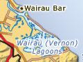
Wairau Bar
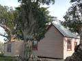
Locality at the mouth of the Wairau River, known to Māori as Te Pokohiwi, where a gravel bar impeded navigation between the river and the open sea. The 1848 earthquake improved navigation over the bar and provided better boat access into the Wairau and Ōpawa rivers. The 1855 quake lowered the land by 60 cm in places, improving access even further. The pilot’s house at Wairau Bar was built in 1868.
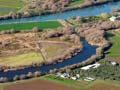
Wairau lagoons and boulder bank
Also known as the Vernon lagoons, the result of sea currents forming a boulder bank. Māori trapped eels and birds, and may have narrowed existing water courses to make it easier to trap fish.
A three-hour walking track leads around the lagoons. The wreck of the SS Waverley was to be sunk at the mouth of the Wairau River to form a breakwater, but floodwaters swept it into the lagoons instead, where it is still visible.
In 1942 early Polynesian human remains and artefacts were uncovered at the northern end of the boulder bank. In 2009, after representations by Wairau Māori, the remains, which had been stored at Canterbury Museum in Christchurch, were reburied at Wairau Bar. They are located on a reserve closed to the public.
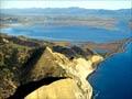
Rārangi
Coastal locality at the northern extremity of Cloudy Bay, 22 km north-east of Blenheim, where the road to Port Underwood leaves the Wairau plain. Rārangi is a popular beach for day visits from Blenheim, with a walking track to neighbouring Whites Bay and glow-worm caves. Idiosyncratic roadside letterboxes create a ‘mailbox alley’.
North of Rārangi
A circuitous route climbs up, then down, the lower flanks of Mt Robertson to Whites Bay. The South Island’s first cable link with the North Island was made here in 1866. The station was staffed until 1896. Since 1977 the restored cable house has been open to visitors.
Early Māori cultivated and walled the flat land at Robin Hood Bay, 10 km from Rārangi. Whalers lived at the bay, probably named after a whaling ship, in the 1830s and 1840s, and a restored house dates from that time. A boys’ boarding school operated there in the late 19th and early 20th centuries.