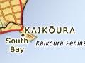
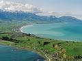
Kaikōura
Windswept town in a dramatic setting between mountains and the coast, on State Highway 1 and the main trunk railway, with a 2013 population of 1,971. Kaikōura is isolated by mountains and hills to both north and south. Before 1900 it had only bridle tracks north and south, and no rail connection in either direction until 1945. Manakau (2,608 m) is the highest summit of the Seaward Kaikōura Range, the peaks of which tower over the coast and the town. Alluvium from the mountains created a plain, and what had been an offshore limestone outcrop became a peninsula.
2016 Kaikōura earthquake
At 12.02 a.m. on Monday 14 November 2016 a magnitude 7.8 earthquake struck New Zealand, causing significant damage to buildings and infrastructure in southern Marlborough and northern Canterbury. Two people were killed.
Kaikōura was an important settlement for early Māori. One name for it was Te Taumanu-o-te-waka-a-Māui (the seat or thwart of Māui’s canoe). In the 1820s and 1830s Te Rauparaha and his allies attacked Ngāi Tahu. Ngāi Tahu retained its mana in the district, but numbers slowly fell.
Early Pākehā settlers, many of Irish origin, struggled to clear the forest and create swamp-free pastures. Kaikōura languished for over a century. Kaikōura’s port has been mostly used by fishing vessels. Rock lobsters (often called crayfish) are a specialty (the town’s name means ‘eat rock lobster’).
On 15 December 1945 the Christchurch–Picton railway was opened at Kaikōura in front of an enthusiastic crowd of nearly 5,000. From 1962 the roll-on, roll-off ferry between Wellington and Picton brought more freight and passenger traffic, both road and rail.
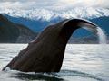
The undersea Kaikōura Canyon brings abyssal depths and sperm whales close to the coast, and whale watching has been a major tourist attraction since the 1980s. A museum, a peninsula walk, natural history and many cafés are points of interest in the town itself. Kaikōura has two other major industries, agriculture and cheesemaking.
One in five of the population identify as Māori. The Takahanga marae of Ngāi Tahu is located above the town centre. The University of Canterbury’s Edward Percival Marine Research Laboratory is in the town.
Goose Bay
Settlement 17 km south of Kaikōura. The highway is squeezed under cliffs after crossing the Kahutara River, then passes through the Paritītahi and Rarama tunnels before reaching the bay. Near Goose Bay the undersea Kaikōura Canyon approaches closest to shore.
A berry good idea
In the 1880s Maungamāunu School’s Māori parents tried to get dispensation for children to be excused from school for two weeks in autumn so they could collect karaka berries.
Mangamāunu
Settlement 16 km north of Kaikōura. In the later 19th century Mangamāunu was a centre of Māori population in the district. A native school opened in 1880, where Australian poet Henry Lawson taught for a few months in 1890.
Ōkiwi Bay
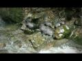
Young seals are guided upstream by their elders to gambol in a fresh-water pool at the base of a waterfall in this scenic reserve 30 km north of Kaikōura.
Visual feast
T. E. L. Roberts cycled from Waikari, Canterbury, to Blenheim to take part in the ballot for the Starborough estate in March 1899. On a new bicycle, a ‘gleaming triumph of individual locomotion’, he arrived in Kaikōura as the sun went down. Roberts wrote that the scenery was ‘a feast for Canterbury eyes. The majesty of those mountains away to the left, with just a little snow on the tops, and with bush running down to the shore, left nothing to be desired, let one’s taste be what it may ... the green cliffs, the blue sea glinting in the sunshine, the white, oh so white foam, dashing on the rugged rocks below the roadway, and anyone ... asking for more could scarcely be satisfied in this world.’1
Clarence River
At 200 km the longest of Marlborough’s major rivers, known to Māori as Waiau-toa. The headwaters of the Clarence are in the Spenser Mountains, very close to the headwaters of the Wairau and Canterbury’s Waiau River (Waiau-ua in Māori). The faulting and blocking that have raised the Kaikōura and neighbouring ranges have shaped the course of the Clarence, while the speed of the mountain-building has prevented it developing a flood plain.
The Clarence flows first south-east for 50 km, passing through the small Lake Tennyson, then due east for 30 km, where it is joined by the south-flowing Acheron, then north-east for more than 80 km, running parallel with the Awatere. It then makes a U-turn through a 12-km gorge, to reach the ocean 40 km north of Kaikōura township.
Kēkerengū
Settlement 56 km north of Kaikōura and 73 km south of Blenheim on State Highway 1. Kēkerengū was a Ngāti Ira chief whose amorous dalliances offended Te Rauparaha and Te Rangihaeata. He fled south, but the northerners followed, and he was killed in the subsequent fighting. St George’s church at Kēkerengū is one of the smallest churches still in use in New Zealand.