
Of the 18,500 Europeans living in the region in 1911 the vast majority were in the gold-mining towns of Waihī, Thames, Karangahake and Coromandel, with smaller numbers involved in logging and sawmilling around Whangapoua, Mercury Bay and Tairua.
The demise of large-scale mining and logging led to population decline on the peninsula and in Waihī in the 1910s and 1920s, followed by slow growth. In 1926 this part of the region had just over 15,000 non-Māori, and in 1961 just under 17,000.
The development of dairying led to a population increase on the plain, with the non-Māori population of Hauraki Plains county rising from around 3,600 in 1921 to 5,752 in 1956. The former mining towns benefited. The population of Thames rose in the 1910s, and again in the 1950s and 1960s; Paeroa’s population rose throughout the period and Waihī’s stabilised.
The Māori population of the region was 1,744 (8% of the regional total) in 1926 and 2,423 (8.9%) in 1961, of whom about two-thirds lived outside the three main towns of Thames, Paeroa and Waihī. In 2013 the Māori population was 18.4% of the total. It was still one-third rural, compared with 16% nationally.
Island living
Only 12 people lived on Coromandel islands in 2006: they were found on Whanganui, Great Mercury and Slipper islands.
Summer peaks and tourism
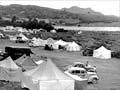
The western coast from Thames to just north of Coromandel town was the part of the peninsula most accessible to Auckland and Hamilton, and after 1945 it was dotted with motor camps and baches (holiday houses). Holidaymakers also made their way over poor roads to Whitianga and the newly established town of Whangamatā on the east coast. The population fell again in the autumn.
More substantial developments took place from the mid-1960s, particularly on the eastern coast, which was easily reached from Auckland and Hamilton with the opening of the Kōpū–Hikuai highway across the peninsula in 1967, and had fewer mudflats than the western coast.
Urban-style subdivision of land took place at Whitianga, elsewhere on Mercury Bay and at Whangamatā. Better-off city dwellers, seeking more comfortable holiday housing and greater services, were the principal buyers. At Pāuanui the Hopper brothers developed an entirely new settlement.
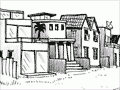
Newcomers to western coast settlements, particularly north of Coromandel town, were more likely to pursue alternative lifestyles on minimal incomes, housing themselves in modest, but often idiosyncratic, dwellings.
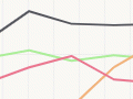
In the early 2000s the summer population on the peninsula increased to around 150,000, six times that through the rest of the year, which put great pressure on roads, water and waste services.
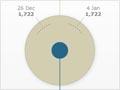
The peninsula also attracts many short-stay (on average four days) domestic and foreign visitors throughout the year: an estimated 2.4 million in 2006, of whom 85% were domestic. On census night in March 2013 the population of the peninsula was 29,394, compared with a usually resident population of just over 26,000.
In contrast to the peninsula resorts, the long-established towns – Thames, Paeroa and Waihī – saw little growth, partly on account of factory closures, whilst local rural populations were more stable.
The year-round labour force in the region worked mostly in industries such as fishing and construction. Service sector employment, other than that provided by schools and hospitals, was concentrated in the retail and hospitality sectors.
A 2013 snapshot
In 2013 Hauraki–Coromandel had a population profile which contrasted with that of the major cities but was characteristic of other parts of the upper North Island that were attractive to retired people and lacked a major urban centre. By comparison with New Zealand’s major cities:
- the 65+ age group was higher
- the under-15 and 15–64 age groups were both lower
- the Asian population was much lower
- the Pacific Island population was much lower
- the Māori population was a little higher.