
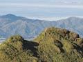

Hauraki–Coromandel is a region of photogenic coastline, relics of gold mining, rich plains and rugged hill country – some still forested, much not – around an hour’s drive from Auckland, Hamilton or Tauranga.
It has two distinct zones: the mountainous, volcanic Coromandel Peninsula and the flat and fertile Hauraki Plains. The region’s ecology and landscape underwent major change in the early years of European settlement as a result of gold mining, logging, kauri-gum digging and drainage schemes. The first three transformed the peninsula, while drainage of wetlands opened the way to farming on the plains. In the later 20th and early 21st centuries, holidaymakers, tourists and migrants from urban life further transformed the peninsula.
The first Coromandel
The territory of the medieval Chola dynasty in south-eastern India was Cholamandalam, which meant the realm of the Cholas in the Tamil language. In the 1500s Portuguese traders turned that into Coromandel, and the usage was adopted by others.
Names and boundaries
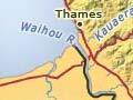
To local Māori the entire region is called Hauraki, encompassing the waters and lands from Mahurangi on the coast north of Auckland to the northern entrance to Tauranga Harbour in the south-east – ‘Mai i Mahurangi ki Ngā Kurī-a-Whārei’ (‘from Mahurangi to Ngā Kurī-a-Whārei’, a prominence just north of the harbour entrance).
The name Coromandel stems from a British ship which collected kauri spars (masts and booms) in 1821. Lieutenant James Cook named the Firth of Thames and called the Waihou River ‘the river Thames’. The region surrounding the river was often called Thames valley until recently, and ‘Thames Valley’ is still used in the name of the local rugby football union and some other district organisations. Hauraki–Coromandel refers to the combined areas of the Thames–Coromandel and Hauraki district councils. Both districts lie within the area covered by the Waikato regional council.
Topography
The Coromandel Peninsula dominates the region. To local tribes the peninsula is a great waka (canoe), its stern at Moehau, near the tip of the peninsula, and its bow at Te Aroha. It divides the waters of the Hauraki Gulf and Te Moana-nui-a-Kiwa – the Pacific Ocean.
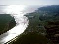
The Hauraki Plains, a drained swamp, are part of the largest single area of flat land in the North Island – the 1,600 sq km Hauraki depression or basin.
Māori settlement
The region has an indented coastline, many islands and swampy lowlands. Water was useful for transport and provided sustenance. Māori navigated coastal waters and exploited the resources they found there. The swamps were valued for eels, waterfowl and materials for building, especially raupō and flax.
Impact of colonisation
Sailing ships and boats gave Europeans ready access to the coasts and inland rivers. James Cook, who travelled up the Waihou River in a longboat in 1769, was the first European to venture inland. The choice of Auckland as New Zealand’s capital in 1840 brought colonising pressures close to Hauraki. Pākehā settlers’ hunger for kauri timber and gold brought them closer still. Hauraki Māori frequently became indebted, with land loss often the result. Most land had passed into settler hands by 1880.
Gold and kauri gum
From 1860 to 1920 timber, gold and kauri gum were exploited to exhaustion, with little consideration for the natural environment. More far-sighted settlers were concerned at the wastage of valuable resources.
Sustainable economics and conservation
Since 1900 dairy farming has been the region’s principal industry. Unlike the economic activities it supplanted, it was sustainable, although continuing intensification of production on the Hauraki Plains has raised concerns about fertiliser and stock effluent runoff into the Firth of Thames.
Holidaymakers and tourists have contributed to the economy since the 1940s. In the 1970s Coromandel became known for its alternative values, communal lifestyles and environmental politics. It is no coincidence that the Values Party, and its successor the Green Party of Aotearoa New Zealand, developed electoral bases in the region. Coromandel resident Jeanette Fitzsimons, co-leader of the Green Party from 1995 to 2009, was a member of Parliament from 1996 to 2010 and represented the Coromandel electorate from 1999 to 2002.
Against this backdrop gold mining resumed at Waihī in 1987, but under strict environmental regulation. However, rehabilitation of worked-out land remained a challenge. In 2010 the government unsuccessfully canvassed opening some high-value conservation land to gold prospecting.