


Until the 1940s mountains, rocky coastlines on the peninsula and wetlands on the plains obstructed movement by land in Hauraki–Coromandel, while long coastlines, rivers and sea access to Auckland promoted movement by water. Gold mining was a great spur to the completion of the branch rail line from Morrinsville to Thames in 1898. An Auckland–Thames road link was only built in the 1930s.
Sea transport
In the absence of land access, settlements were isolated and dependent upon the occasional visits of coastal vessels for communication with the outside world. Ships were built on the peninsula for both Māori and settlers.
The kauri timber trade required sailing vessels to transport logs and sawn timber to Auckland and beyond: first schooners, and from the 1880s scows – shallow-draught vessels capable of carrying twice their tonnage in timber. In the kahikatea timber trade, square-rigged ships delivered cargoes from Tūrua to Sydney and Melbourne.
Northern Steamship Company vessels carried passengers between Auckland and the main settlements of the peninsula. Until the 1940s, and the advent of improved roads, boats were necessary to reduce the isolation of life on the peninsula.
River transport
For centuries Māori used the Waihou River to reach Ōhinemuri and Te Aroha. Europeans were quick to appreciate its importance as a route into the interior. Entrepreneur Josiah Clifton Firth cleared the river by 1880 to improve access to his Matamata estate, but eventually went bankrupt.
Work on clearing the river resumed with the opening of the Ōhinemuri goldfield in 1875. By the 1880s small paddle steamers were plying the river as far as Paeroa. Silting caused by mine tailings was a constant problem, but passenger traffic continued until the 1920s, and barge traffic until the mid-1950s.
On the Hauraki Plains only travel by water was possible until well into the 20th century. The drainage scheme included the building of many wharves. A passenger steamship service operated on the Piako River from 1910 to 1932, and a freight service until 1948.
The wires
The telegraph line between Auckland and Wellington, opened in 1872, went across hill country between Whangamatā and Hikutaiā because a line through the Ōhinemuri gorge was unacceptable to Ngāti Tamaterā and its chief Te Hira Te Tuiri. In 2010 Wires Road and the Old Wires Track at Maratoto, north-east of Paeroa, were reminders of its route.
Railways and roads
Gold mining accelerated the making of a rail link. Transporting mining equipment, coal and building supplies from Paeroa to the gold workings by horse teams was expensive. Coal from Huntly was needed to run a ‘big pump’ for the mines at Thames. The rail line reached Paeroa in 1895, Thames in 1898 and Waihī in 1905.
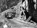
The Paeroa–Te Aroha road was opened in 1881 and a daily Paeroa–Thames coach service began a year later. Communities on the peninsula had to wait until after 1945 for reliable connecting roads.
Gold mining, which the railway was introduced to serve, ended in the 1920s – except at Waihī. The rail service to Waihī continued until 1978, when the completion of the Kaimai tunnel opened a direct route between Waikato and the Bay of Plenty. The service to Paeroa and Thames continued until 1985.
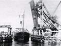
The swing-span
The central 47.2 metres of the historic Kōpū bridge turned on a central pier, providing passage for medium-sized vessels. After remaining closed for some years, it was opened several times in 2002 for a tourist boat.
Kōpū bridge
The Kōpū bridge across the Waihou River, which filled the final gap in the Auckland–Thames road in 1928, sealed the transition from river (and rail) to road transport in the region. It is the only surviving swing-span road bridge in the country, but in summer its single lane caused major traffic jams.
Work on a new 580-metre two-lane Kōpū bridge began in 2009. It was opened in December 2011, in time for holiday traffic. In 2018 the Kopu Bridge and Community Trust planned to restore the bridge for use by pedestrians and as a cycleway adjacent to the Hauraki Rail Trail.