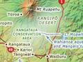

The Waimarino district lies at the foot of the 2,797-metre volcano Mt Ruapehu. The region's main rivers – the Manganuioteao, the Mangawhero and the Whangaehu – all have their headwaters on the mountain's slopes.
Raetihi
Town on the Waimarino plain, 89 km north-east of Whanganui at the junction of State Highways 4 and 49. It was founded in 1892 on the Waimarino block, which the government bought in 1887. Until the main trunk railway reached Ohakune in 1907, Raetihi was reached via the Whanganui River and a dray road built from Pipiriki in 1893. A branch railway line was built to the town in 1917.
In March 1918, massive forest fires destroyed pasture, stock, sawmills and property, and caused three deaths. But sawmilling thrived until the 1930s – over 20 mills operated in the district in the mid-1920s.
Near the distinctive Rātana church is a marae of Ngāti Uenuku, a sub-tribe of Te Āti Haunui-a-Pāpārangi.
Pastoral farming and market gardening have been the mainstay of Raetihi’s economy since the 1930s, but have not stimulated growth. The dairy factory closed in 1966, the branch rail line in 1968, the council offices in 1989, and the hospital and bank in the 1990s. The population fell from 1,219 in 1976 to 1,002 in 2013.
Pat O’Connor, the world heavyweight wrestling champion from 1959 to 1961, was from Raetihi.
Two towns
Raetihi was established in 1892 on the dray road from Pipiriki, the main route to the Waimarino district at the time. Ohakune, 11 km east, began life as a camp for workers building the main trunk railway. For that reason it grew faster, gaining a town council in 1908. Raetihi did not follow suit until 1913.
Ohakune
Town on the Waimarino plain, 100 km from Whanganui, on State Highway 49. A long-established pā, Maungarongo, is the home of Ngāti Rangi, a sub-tribe of Te Āti Haunui-a-Pāpārangi. Ohakune was founded in 1895 on the Waimarino block, which the government bought in 1887. Like Raetihi, it was reached via the Whanganui River and dray road from Pipiriki until the railway arrived in 1908 and made it a rival to the older settlement. By 1921 Ohakune’s population (1,535) was almost double that of Raetihi.
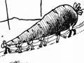
Ohakune developed both on its original site and by the railway. Much of the district’s wealth comes from market gardening, started in 1925 by several Chinese families on the fertile volcanic soils. Ohakune is often called the ‘carrot capital’, and a model of a giant carrot stands at the town’s entrance.
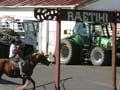
Market gardening coexists with pastoral farming, and with exotic timber milling at Karioi and Tangiwai. The Tūroa skifield on the slopes of Mt Ruapehu was opened in 1979, and other kinds of outdoor recreation are also popular.
The town’s resident population of 1,399 in 1976 fell to 987 by 2013, but is boosted by many hundreds during the ski season.
Rangataua
Settlement 5 km east of Ohakune, once a sawmilling centre, but now a reserve of native forest, including the Rotokura Ecological Area, where native bush surrounds two small lakes. Rangataua Forest is a sacred place of Ngāti Rangi.
Karioi
Farming and forestry locality, 13 km east of Ohakune. The region’s first exotic forest was planted here in 1927, and trees have been harvested since the late 1960s. In the 2010s a pulp mill operated at Karioi and a sawmill at Tangiwai, both owned by Indonesian firm WPI International.
Whangaehu River
The Whangaehu emerges from the Whangaehu Glacier on the east flank of Mt Ruapehu and flows eastwards across the Rangipō Desert, then south-west for some 137 km to the Tasman Sea south-east of Whanganui. Water from its tributaries is delivered via the 8.4-km Wahianoa aqueduct to Lake Moawhango, and then to the Tongariro power scheme.
In 1953, a lahar (volcanic mud flow) from Ruapehu’s crater lake surged down the Whangaehu and destroyed the rail bridge at Tangiwai. The overnight train plunged into the river, causing 151 deaths. In February 2004 the river rose 11 metres in places, wreaking havoc in its lower reaches.
Waiōuru
Township, and since 1940 an army base, at the junction of State Highways 1 and 49, 29 km north-west of Taihape at the south end of the Desert Road. A stopping point for many travellers, the National Army Museum is a major attraction. The 2013 population of 741 is mostly army-related. The population dropped by 639 between the 2006 and 2013 censuses because the New Zealand Defence Force cut permanent staff numbers.
Irirangi
Locality 8 km south of Waiōuru on State Highway 1. A naval radio station opened there in 1942 and was commissioned as HMNZS Irirangi in 1951, but it was decommissioned in 1993. The communications equipment is now operated remotely from Auckland.