Westmere
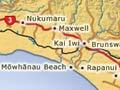
Locality 6 km north-west of Whanganui, with market gardens, poultry farms, horticultural holdings, lifestyle blocks, and Westmere Lake, a wildlife reserve. The redoubt (fortification), known as ‘Headquarters’, was the base for troops in the Waitōtara campaigns of the mid to late 1860s. In the 1920s and early 1930s, a field at Westmere was used as Whanganui’s first airstrip.
Brunswick
Locality 11 km north-west of Whanganui, with livestock farming and lifestyle blocks. Its first settlers came from New Brunswick in Canada in 1853, and the politician John Bryce farmed there for 50 years. The killing of settler and provincial councillor James Hewett by Māori in 1865 prompted the building of four redoubts.
Rapanui
Locality 14 km north-west of Whanganui. The former Bason farm has been developed since 1970 as the Bason Botanic Gardens; some 70,000 bricks from Whanganui’s old Majestic Cinema were used in the display centre and conservatories.
Mōwhānau Beach
Beach settlement 15 km north-west of Whanganui. Alexander’s redoubt was built there in 1865. Tītokowaru’s fighters raided the area in 1868 – the closest they got to Whanganui.
Kai Iwi
Settlement 15 km north-west of Whanganui, the home of Ngāti Pūkeko and Ngāti Iti, sub-tribes of Ngā Rauru. Woodall’s redoubt was built in 1864; Kai Iwi settlement developed after hostilities ceased in mid-1869. Bushy Park homestead is about 10 km further inland.
Pākaraka (formerly Maxwell)
Settlement 24 km north-west of Whanganui. Maxwell was laid out as a township in 1871 by Robert Pharazyn, a Wellington provincial councillor, and was named after a settler killed in conflict with Māori. In 2022 Maxwell was renamed Pākaraka, the name of the marae of Ngāti Maika, a hapū of Ngā Rauru.
Nukumaru
Locality 28 km north-west of Whanganui. Several encounters occurred here during the hostilities of the 1860s. In February 1869 Taurangaika, the stronghold of Ngāti Ruanui leader Tītokowaru, was found abandoned by colonial forces led by Colonel George Whitmore.
Waitōtara River
River flowing 80 km southwards from the Matemateaonga Range, entering the Tasman Sea about 7 km south-west of Waitōtara. It passes through dense native forest for 30 km from its source, and through steep, rugged country until just north of Waitōtara.
Many pā were sited along the river valley. European settlement reached upriver through the 1880s and 1890s, reaching Makākaho, Ngāmatapōuri and Taumatatahi. St Hilda in the Wood church at Ngāmatapōuri was designed by John Swan in 1900, and built of local timber.
Waitōtara
Locality 34 km north-west of Whanganui, with a 2013 population of 66. The township was laid out on the north bank of the Waitōtara River in 1873, and the river was bridged in 1874. In February 2004 the entire settlement was flooded. Flooding in July 2006 also caused damage.
Why Waverley?
Wairoa’s name was changed to Waverley in 1876 to avoid confusion with other towns called Wairoa. Many of the area’s early settlers came from Scotland – they chose the new name in memory of Sir Walter Scott, whose books had become known as the Waverley novels.
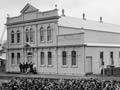
Waverley
Township 47 km north-west of Whanganui, with a 2013 population of 798. It was established as the military settlement of Wairoa in 1866. Between 1893 and 1925 the Department of Agriculture ran an early experimental farm at nearby Moumāhaki.
From 1971 to 1988 coastal ironsands from nearby Waipipi were shipped to Japan. Famous sons of Waverley include Kiwi, winner of the Melbourne Cup in 1983, and his owner–trainer, E. S. (Snow) Lupton.
There are rock carvings of lizard and bird-like shapes at Kōhī, 11 km north-west. Writer, teacher and activist Rewi Alley lived in a cottage in the Moeawatea Valley from 1920 until shortly before he left for China in 1927. The old boundary between the Wellington and Taranaki provinces is crossed 10 km west of Waverley.