Queen’s Park
A significant group of buildings was constructed at Queen’s Park between 1919 and 1933, and added to in later years.
- The Sarjeant Gallery (1919) was funded through a bequest from early settler Henry Sarjeant. Its collection includes work by local artist Edith Collier and local-born glass engraver John Hutton.
- The Whanganui Regional Museum building was constructed in 1928.
- The Alexander Heritage and Research Library (1933), which, along with the museum, was built through bequests from Elizabeth Alexander.
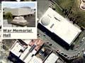
- The 1960 War Memorial Hall commemorates the fallen in the Second World War and is an outstanding example of mid-20th-century modern architecture.
- The Wanganui District Library (also known as the Davis Library) was built in the 1980s with bequests from the Sydney and Prudence Davis Trust and public subscription.
An appropriate site?
Te Āti Haunui-a-Pāpārangi leader Hoani Wiremu Hīpango, who fought against the upper-river Hauhau group, was killed in battle in 1865 and is buried on Korokota hill. Missionary Richard Taylor named the hill for Golgotha, where Jesus was crucified. Taylor had found the area littered with bones, probably from a battle with Te Rauparaha in the late 1820s, when hundreds of locals were killed.
Moutoa Gardens
Park adjacent to the river, known to Māori as Pākaitore; a place where Māori distributed their fish catch and later traded with the townspeople. It was named Moutoa Gardens after the 1864 battle at Moutoa Island, where lower Whanganui Māori repelled war parties from the upper river.
For 79 days in 1995 the domain was occupied by Māori, mainly with upriver affiliations, and their supporters. Their demonstration over ownership of the park also became a protest about the loss of traditional rights. The occupation ended peacefully on 18 May, and an agreement was later signed between the Crown, district council and Māori, vesting the land with the Crown and its management with a board that included people from Whanganui tribes.
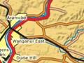
Durie Hill
Suburb across the river from downtown Whanganui, named after an early resident magistrate. Its development was assisted by the construction of a 213-metre pedestrian tunnel leading to a 66-metre elevator running up through the hill – New Zealand's only earthbound elevator. A large part of Durie Hill was designed in 1919 by Samuel Hurst Seager as a garden suburb. From the 33.5-metre-high First World War memorial tower the entire regional landscape, as far as the mountains Taranaki and Ruapehu, is visible. Nearby Bastia Hill is the site of a 50-metre-high water tower.
St Johns Hill
High-income suburb on the road to New Plymouth. Various streets and reserves, including at Virginia Lake (formerly Rotokawau), were planted with native and exotic trees by a beautifying society formed in 1910.
Not on my patch
After the gang-related killing of two-year-old Jhia Te Tua in Gonville in 2007, Wanganui District Council proposed a bylaw to ban gang insignia from the city’s public areas. The law was then upgraded to a parliamentary bill, sponsored by Whanganui MP Chester Borrows. In May 2009 the bill was passed, and on 31 August Wanganui District Council passed a bylaw banning gang insignia in public places.
Castlecliff and Gonville
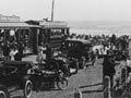
Port facilities were developed at Castlecliff from 1911. State (public) housing was built there and at Gonville, the site of a freezing works. Castlecliff beach was popular with locals. By the 1950s the port trade was mostly coastal; it declined from the 1960s after the roll-on, roll-off Cook Strait ferries were introduced.
In the 2010s the port handled fish, cement, timber and grain, and a number of factories, including the freezing works, were located nearby. Part of Balgownie swamp had become a wetland reserve (Kokohuia), and the rest had become an industrial area, after having been the city tip for some years.
Wanganui East
The long-time home of the Eastown railway workshops, established in 1892. The main railway station was across the river at Aramoho. New Zealand Railways became one of the city’s largest employers, and several hundred jobs were lost when the railways were downsized. The workshops closed in 1986. From 1959 part of the Esplanade at Wanganui East was developed into Kōwhai Park playground by the Jaycees.
Pūtiki
The marae of Ngāti Tūpoho and Ngāti Tūmango and the oldest part of Whanganui, across the river and downstream from the city centre, at the junction of State Highways 3 and 4. The full name, Pūtiki-Wharanui-a-Tamatea-Pōkaiwhenua (the place where Tamatea tied his topknot with flax), commemorates the early ancestor and explorer Tamatea, of the Tākitimu canoe.
A mission station was established at Pūtiki in 1840. Richard Taylor served there from 1843 until 1866, and his son, Basil Taylor, from 1860 to 1876. Descendants of the missionary Henry Williams also gave lengthy service. The meeting house, Te Paku-o-te-Rangi, replaced an earlier house destroyed in an 1891 flood. St Paul’s Church, the fifth to occupy the site, has fine modern carvings. Nineteenth-century leaders Mete Kīngi Te Rangi Paetahi and Te Keepa Te Rangihiwinui are both buried at Pūtiki.