Gathering data
At some sites in New Zealand daily weather records have been collected since the 1840s. For a long time these observations were made by volunteers and government employees. By the mid-20th century many observers were setting off for their climate stations at 9 o’clock each morning to read the rain gauge, record the night’s minimum temperature and the previous day’s maximum, and replace the sunshine recorder card. Manual records were taken every hour at a few airports. At the peak of manual data collection in the early 1970s there were more than 1,300 people observing the weather in New Zealand. In the early 2000s about 750 manual observations were made every day, and about 130 automatic weather stations made recordings every hour.
Stevenson screens
Temperatures in New Zealand are measured using louvred wooden boxes called Stevenson screens. Air flows through the box, which contains thermometers sheltered from direct sunlight and rain. The boxes are mounted 1.3 metres off the ground.
Archives
Understanding our climate involves countless analyses of data, and the longer the data has been collected, the better the analysis. However, it needs to be stored and made accessible. There are two archives in New Zealand of national importance: the National Climate Database, housed at the National Institute of Water and Atmospheric Research (NIWA) in Wellington, and the National Water Resources Archive, housed at NIWA in Christchurch. These databases have over 270 million records from 5,900 land-based climate stations, and 10 million ship-based records.
Derived data
Apart from raw data, there are also derived data records such as summary statistics tables which list monthly and annual averages, extremes or totals of rain, air temperature, atmospheric pressure and wind. Information about temperatures above or below certain critical thresholds are important for growing crops or heating houses.
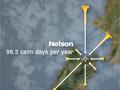
This information can be used to generate wind roses, which are diagrams showing prevailing wind direction. The data can also help anticipate heavy rainfall, and gauge weather in places between climate stations.