Modern weather forecasting depends on detailed knowledge of current conditions.
Surface surveillance
In New Zealand, observations of weather conditions at the earth’s surface are made at about 100 places every hour, and at some places every 10 minutes. They are made mostly by machines, and some are made by people. Variables measured include air pressure, temperature and humidity, wind speed and direction, visibility, the level of the cloud base and the amount of cloud, as well as rainfall. Reports taken by people include rain visible in the distance, cloud type and the presence of snow or hail. In some places webcams are available.
Getting it right
People often complain that forecasters get their predictions wrong. This might be because forecasts need to be presented simply and clearly, underplaying any scientific complexity. It might surprise the critics to know that a five-day forecast in 2003 is as accurate as a one-day forecast was in the 1950s.
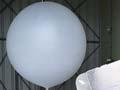
Weather balloons
Since the early 20th century, surface surveillance has been supplemented by weather-balloon observations. The balloons are tracked with radar to ascertain wind direction and speed at different altitudes, and temperature and humidity throughout the atmosphere. Their limited coverage over oceans is compensated for by satellite-borne instruments, which can accurately measure the air temperature at different altitudes.
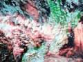
Satellites
Different types of satellite images taken over the Tasman Sea and New Zealand are received hourly, 24 hours a day:
- Visual images show reflected light and clouds as small as 1 kilometre in diameter
- Infrared images show heat radiation emitted by clouds, land and sea surfaces
- Microwave images of clouds indicate where rain is falling and help to locate the eyes of tropical cyclones
- Water-vapour images highlight areas where cloud may form.
Some satellites are also able to measure the air temperature at different heights, or surface winds over the sea. This is especially beneficial for forecasting in the southern hemisphere, where there are large areas of open ocean. These satellites make tens of thousands of observations every day for regions that would otherwise have only a handful of ship reports and drifting buoys.
Other data gathering
Weather radar, operated by MetService, covers about 80% of New Zealand. It detects rain and hail and estimates their intensity, and can record wind speed and direction. A lightning-detection network helps keep track of thunderstorms. Some commercial aircraft provide high-altitude wind and temperature measurements.