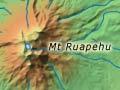
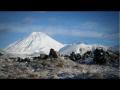
Tongariro
At 1,967 metres, Tongariro is the lowest of the three central North Island volcanoes. Its name is used by Ngāti Tūwharetoa to refer to the whole volcanic complex, and it is the name of the national park which embraces all three peaks. The name means ‘seized by the cold south wind’, and recalls the ancestor Ngātoroirangi, who climbed the mountain in a bitter southerly. Freezing, he called to his sisters in Hawaiki to send fire.
Like nearby Ruapehu, Tongariro is a truncated cone with a number of separate peaks in a broadly circular pattern. Its only major active vent is Ngāuruhoe, considered a separate mountain.
Ngāuruhoe
This graceful near-symmetrical 2,287-metre cone is the most active of the North Island volcanoes. It was named after Ngātoroirangi’s slave Uruhoe, who died on the mountain. Geologically speaking it is Tongariro’s youngest vent – probably no more than 5,000 years old. The trader John Carne Bidwill climbed Ngāuruhoe in 1839, ignoring a Māori tapu (spiritual restriction).
The climber is rewarded by a sulfur-smelling glimpse of a live volcanic crater, and the mountain’s even slopes allow summer sliding and winter skiing. Ngāuruhoe’s last major eruptions were in 1974–75.
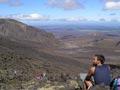
Tongariro Crossing
The Tongariro Crossing is a strenuous 17-kilometre hike into an extraordinary volcanic landscape. In summer, several hundred people complete it each day. After a steep climb to the saddle between Tongariro and Ngāuruhoe, the walk skirts Tongariro’s Red Crater, the thermal Emerald Lakes, Blue Lake and the Ketetahi hot springs. It forms part of the Tongariro northern circuit, one of the Department of Conservation’s Great Walks, which circles Ngāuruhoe as well.
Te Kooti takes cover
The Crown pursued Māori leader Te Kooti across the North Island in 1869, reaching the Rotoaira area. South-east of the lake, government forces established McDonnell’s redoubt; to the west, Te Kooti fortified Te Pōrere. After his defeat there on 4 October he retreated into the King Country.
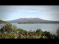
Lake Rotoaira
Lake (12 sq km) between Pīhanga to the north and Tongariro to the south. Rotoaira is naturally fed by runoff from both mountains and from swampland to the west. It has an outlet to the Tongariro River. As part of the Tongariro hydroelectricity scheme, Rotoaira is a reservoir for waters diverted from the Whanganui, Whangaehu and Moawhango rivers and their tributaries. Water is fed from channels to the west and east, then taken to the Tokaanu power station through a tunnel. Ngāti Hikairo, a hapū of Ngāti Tūwharetoa, have marae at nearby Otukou and Papakai.
Pīhanga and nearby mountains
The volcanic peaks of Pīhanga (1,325 metres), Tīhia (1,166 metres), Kākaramea (1,301 metres) and Kuharua (1,129 metres) rise behind the southern shore of Lake Taupō, above Lake Rotoaira. The mountains are overshadowed by Tongariro, Ngāuruhoe and Ruapehu to the south, but have a distinctive presence.
In Māori tradition, the beautiful Pīhanga was fought over by four other mountains – Tongariro, Taranaki, Tauhara and Pūtauaki (Mt Edgecumbe). The bush-clad summits of Pīhanga and Tīhia are in an outlying part of Tongariro National Park, while Kākaramea and Kuharua are covered in farmland as well as bush. The silhouetted view of the mountains from Taupō town on a clear summer evening is a memorable one.
Te Ponanga saddle road follows a scenic route through native forest between Pīhanga and Tīhia. A walking track leads from the road to small Lake Rotopounamu, formed by a landslide about 10,000 years ago.