Kāingaroa Forest
Exotic forest occupying a large part of the Kāingaroa plateau. The state-owned forest was planted in the 1920s. Its logging, from the 1950s, prompted the development of a pulp and paper industry at Kawerau. The forest was sold by the Crown in the 1980s. In the 2010s it was managed by Kāingaroa Timberlands on behalf of Harvard University and the New Zealand Superannuation Fund.
Kāingaroa village
Established after the Second World War, by 1951 Kāingaroa had more than 90 houses. A primary school, butchery and general store were built, and other amenities followed. The town was handed over to its residents by the Crown in 1987, after the state’s forests were privatised. In 2013 the population was only 426, and there were many empty sections and derelict houses. A memorial to forester Roderick Macrae (1873–1955) was erected by the New Zealand Institute of Foresters in 1956.
From war to peace
At Ōpepe, south-east of Taupō, the war leader and prophet Te Kooti ambushed encamped colonial forces in June 1869, killing 9 men. An armed constabulary fort stood on the site for some years thereafter. Today it is a historic reserve with a remnant stand of native bush.
Wheao power station
The 26-megawatt power station on the Wheao River, a tributary of the Rangitāiki River, was commissioned in 1980. It began operation in 1984 after long delays – in 1982, the canal bringing water from the river had collapsed and the station had been overwhelmed by boulders.
Rangitāiki
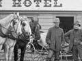
Locality on the Taupō–Napier road, 36 km south-east of Taupō. Rangitāiki is named after the river, which the highway crosses at this point. It was an accommodation stop when the trip from Taupō to Napier took days, not hours. It still has a hotel, which is a meeting place for local farm workers.
Lake Taupō Forest
Lake Taupō Forest lies between State Highway 5, Lake Taupō and the Kaimanawa Range. It is owned by the Lake Taupō Forest Trust, which was set up in 1968 and represents the interests of a large number of Ngāti Tūwharetoa owners.
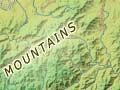
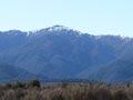
Kaimanawa Mountains
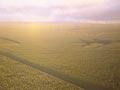
One of the North Island’s main ranges, south-east of the Volcanic Plateau. The junction between the range and the plateau can be clearly seen from the Desert Road, where the greywacke of the ranges is succeeded by ignimbrite erupted from the Taupō Volcanic Zone. The streams from the range’s northern slopes feed Lake Taupō.
The summits mostly reach just over 1,500 metres. Umukarikari (1,592 metres) is visible from the Desert Road; Makoroko, the highest peak (1,727 metres), lies further east. The range is forest-clad to about 1,300 metres, mainly in beech. Mostly comprising a forest park, the Kaimanawas are popular with hunters and trampers.