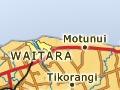

Waitara
Town 16 km north-east of New Plymouth, with a 2013 population of 6,483.
History
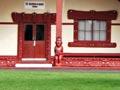
Waitara has been settled for hundreds of years. Some of the earthworks of the extensive early pā, Manukorihi, survive in the grounds of Manukorihi Intermediate School on the bluff overlooking the town. Ōwae, Te Āti Awa’s central marae, also stands within the pā. Its meeting house, Te Ika-roa-a-Māui, was completed in 1936, when the statue of politician Māui Pōmare was erected.
Whai-tara-nui
The name of Waitara town is said to be derived from the story of Whare Matangi, the estranged son of Ngārue. He was given a magic dart (tara) that would lead him to his father. After a number of throws, the tara struck Ngārue’s house at the mouth of the river, thereafter known as Te Whai-tara-nui-a-Ngārue (follow the dart of Ngārue). This story was illustrated on the Ōwae marae entrance gate by carver John Bevan Ford in 1973.
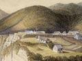
British troops used the Waitara River for access in 1860, when a dispute over the purchase of the Pekapeka block (west Waitara) led to the first Taranaki war. The military camp established on what is now Pukekohe domain became the centre of operations in the Waitara area during the war.
Originally known as Raleigh, the township was established in 1867. In 1904 it was renamed Waitara after the river. For most of the 20th century Waitara’s economy was based on the large Borthwick’s freezing works, which opened in 1885. The works closed in 1997, a casualty of ageing facilities and changing international market conditions.
The Waitara port was established near the town bridge, but the bar at the rivermouth prevented large vessels from entering. The port was decommissioned in 1941.
The first Taranaki Māori festival was held in Waitara in November 2009, involving people from the region’s eight tribes.
People
In 2013, 39.9% of Waitara residents identified as Māori, compared with 17.4% regionally and 14.9% nationally.
Motunui
Locality 3 km east of the Waitara River on State Highway 3. Motunui is home to the Methanex methanol plant, built in the 1980s as the Synfuel synthetic petrol plant.
Tikorangi
Small rural settlement 6 km south-east of Waitara. Tikorangi was established near two 1865 redoubts. In the early 20th century it had a dairy factory, school, general store, blacksmith and St Luke’s Anglican Church (1901).
Onaero
Settlement 10 km east of Waitara on State Highway 3. The Onaero domain, at the mouth of the Onaero River, is a small beach camp. To the north, Onaero Beach settlement has a number of permanent residents.
Urenui
Rural service centre 16 km east of Waitara, with a 2013 population of 426. The Ngāti Mutunga people are centred on Urenui, and Ruapekapeka marae is on the township’s eastern boundary. A few kilometres north-east is Ōkoki pā historic reserve, where the ashes of Te Rangi Hīroa (Sir Peter Buck) are interred under a stylised canoe-prow memorial. The township began as a military settlement around the Urenui redoubt in 1865. The beach camp at the rivermouth is a popular summer holiday spot.
Urutī
Settlement 34 km north-east of Waitara at the junction of the flood-prone Urutī and Mimi streams. Urutī was the first place in New Zealand to have a backblocks district nurse, in 1909. The 2003 movie The last samurai was filmed in the Urutī valley.
Pukearuhe
Coastal settlement 30 km north-east of Waitara. Ngāti Tama’s fortress of Pukearuhe pā at the southern end of Parininihi (the White Cliffs) guarded the entrance to Taranaki for many centuries. The iwi’s modern marae is a kilometre or so south.
In 1865 Pukearuhe was occupied by the 70th Regiment and Taranaki Bushrangers, who built a redoubt and blockhouse. It remained a military outpost until 1885. Clifton township was surveyed around it, but did not develop much beyond housing for the garrison’s families. In 1869 the redoubt was attacked by a Ngāti Maniapoto war party which killed the eight residents and the visiting missionary John Whiteley.
The White Cliffs (Parininihi)
Natural landmark between Pukearuhe and Tongapōrutu. The bush-clad ridges of the inland hill country reach the sea to form the towering 245-metre grey mudstone ramparts. The 9.6-km White Cliffs Walkway crosses the area and follows the natural-gas pipeline corridor. A tunnel at Te Horo was completed in 1889, allowing travellers and drovers to avoid the near-impassable Ruataniwha or Rigby’s Point (named after Constable John Rigby, who drowned there while swimming horses around the point).
A moving frontier
The Mōkau River was the old northern boundary of Taranaki, and Mōkau residents still maintain close links with the province. The present boundary is the Mōhakatino River watershed, a few kilometres south of Mōkau.
Ahitītī
Ahitītī was named after the Māori practice of lighting ridgetop fires (ahi) to attract tītī (petrels or muttonbirds) as they returned to their nesting colonies in the hills.
Tongapōrutu
Tongapōrutu is a popular holiday area, with a beach accessible at low tide. Pou Tehia historic reserve, at the northern end of the bridge, is a pā with a family memorial to Thomas McClutchie, a scout for the military during the Taranaki wars.