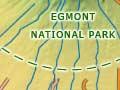

Waimate plain
The Waimate plain, north-west of Hāwera on the southern ring plain, was once one of New Zealand’s most densely populated rural areas. There were small communities, often centred on a dairy factory or school, at nearly every intersection of the grid of roads in the area. However, Mākākā, Te Kiri, Awatuna, Riverlea, Auroa, Mangawhero, Mātapu, Ōtākeho, Ōeo and Mangatoki all but disappeared in the later 20th century. The district’s population fell sharply during this period – the population of Waimate West County dropped from 2,788 in 1951 to 1,944 in 1981. The closure of many schools in 2004 and 2005 was the final blow for many townships.
Kaponga
Settlement on the northern edge of the fertile Waimate plain 13 km west of Eltham, with a 2013 population of 303. In the early 20th century Kaponga vied with neighbouring Manaia to be the area’s main rural service township, but Manaia won.
Hollard Gardens is a formerly private garden planted by Bernard Hollard from 1927. Now administered by the Taranaki Regional Council, it is open to the public.
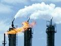
Kāpuni
Settlement, and site of natural gas field, 19 km south-west of Eltham. The 1959 discovery of the Kāpuni field of gas and condensate (light, liquid hydrocarbons) began the modern era of the petroleum industry in Taranaki. Since then, the area has been one of Taranaki’s centres of the petrochemical industry. The natural gas processing station separates gas and condensate and then supplies the gas to the Natural Gas Corporation for distribution. Ballance Agri-Nutrients, which was set up as Petrochem in 1982, manufactures urea fertiliser from natural gas in its nearby plant.
Fonterra Kapuni is a lactose (milk sugar) plant that opened in 1947. Lactose, for use in pharmaceutical products, is extracted from whey, a by-product of cheese manufacture at the Whareroa factory near Hāwera.
Swiss immigrants settled around Kaponga and Kāpuni in the late 19th and early 20th centuries, and a number of their descendants still farm in the area.
Near Kāpuni is Te Ngutu-o-te-manu domain – the site of a battle in 1868 in which Ngāti Ruanui leader Tītokowaru routed a colonial force of Armed Constabulary and Forest Rangers. Flamboyant Prussian soldier Gustavus von Tempsky was killed in this battle.
Ōkaiawa
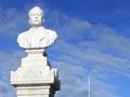
Settlement 14 km north-west of Hāwera. In the 1880s Ōkaiawa was the centre of Thomas Joll’s chain of private dairy factories, which turned cooperative after Joll’s death in 1908. He is commemorated by a marble bust near the sportsground on the Ōkaiawa domain.
Kaūpokonui
Settlement 17 km west of Hāwera on State Highway 45. Kaūpokonui (the great headland) was named by Turi, captain of the Aotea voyaging waka (canoe). The popular beach camp at the Kaūpokonui River mouth has been populated for hundreds of years and was the site of a moahunting settlement around 1300 CE.
Kaūpokonui was the site of one of Taranaki’s largest dairy cooperative factories until 1975, when it amalgamated with the T. L. Joll Co-operative to form Kiwi Co-operative Dairies.
The wreck of the Lizzie Bell
In July 1901 the iron barque Lizzie Bell ran aground on a reef near the mouth of the Ōeo Stream while sailing from Wellington to Australia. All 18 crew were able to get into the lifeboat, but it was overturned by the heavy seas. Twelve seamen died of exposure before the others could get help from local farmers. Ten bodies were recovered and are buried in the Pīhama cemetery.
Pīhama
Settlement 34 km north-west of Hāwera. Pīhama is named after Hone Pīhama (John Beecham), a local chief who provided protection for Pākehā surveyors in the 1880s. The gateway and ‘provision house’ (elevated storehouse) at nearby Ōtūmātua pā were painted by Charles Heaphy in 1840, while he and a party of surveyors were on their way to lay out the site of New Plymouth.
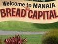
Manaia
Township 15 km north-west of Hāwera, with a 2013 population of 960. Manaia was named after Hukunui Manaia, a paramount Māori chief of the district. It was the administrative centre of the Waimate West County Council and Manaia Town Board until both became part of South Taranaki District in 1989.
The town is surrounded by some of the richest dairy land in the country. In the 1940s and 1950s the ratio of dairy factories to kilometres of road was the highest in New Zealand. To help transport milk to the factories, Waimate West County began a major road-sealing project in 1916 and within a few years had some of the country’s best rural roads.
In the town’s central crossroads, an 1890 marble obelisk commemorates the Pākehā casualties of the 1868–69 Taranaki wars; a second obelisk and a band rotunda are First World War memorials. The Manaia redoubt has two 1880s blockhouses and a 1912 replica of the original lookout tower. Manaia is the site of Yarrows bakery, founded in 1923.
The onshore production station for the offshore Kupe oil and gas field is near the mouth of the Kāpuni River, 4 km south-east of the town.