Image
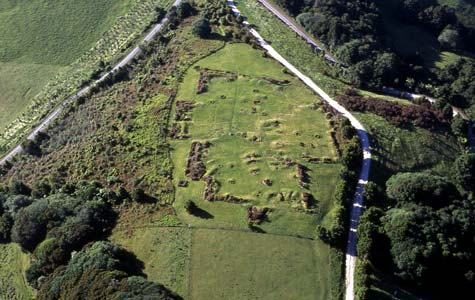
Ruapekapeka pā, 14 kilometres south-east of Kawakawa, was the site of the last battle in the northern war between British forces and chiefs of Ngāpuhi and associated tribes. Designed by Ngāti Hine chief Te Ruki Kawiti, the massive fortification included bomb-proof shelters. There is extensive interpretation at this important historic site.
Te whakamahi i tēnei tūemi
by Kevin Jones
This item has been provided for private study purposes (such as school projects, family and local history research) and any published reproduction (print or electronic) may infringe copyright law. It is the responsibility of the user of any material to obtain clearance from the copyright holder.