

Kaikohe
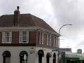
Town approximately halfway between Hokianga and the Bay of Islands. Kaikohe is the administrative centre for the Far North district, serving the surrounding farming area.
In 2013 its population was 3,915. 77.9% identified themselves as Māori.
Māori historical associations are significant. The Northern War leader Hōne Heke died in Kaikohe in 1850. A memorial on Kaikohe’s 300-m hill celebrates his grandnephew, Hōne Heke Ngāpua, a member of parliament and active supporter of the Māori parliamentary movement known as Kotahitanga.
Kaikohe was a small Ngāpuhi settlement until a rail link south was made in 1914 and dairy farming developed. After the First World War returned servicemen settled there, and then in the Second World War it was a base for an American army hospital and air force bomber unit. Today some of this history is presented at Kaikohe’s pioneer village and museum.
In the early 21st century the community was divided over locating a prison at Ngawha. Some local concerns about its effects on existing gang problems were realised, but since opening in 2005, the Northland Regional Corrections Facility has also become a leader in arts programmes for inmates, winning an Arts Access Corrections Leadership Award in 2016.
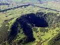
Taiamai Plains
Rolling farmland surrounding Kaikohe, with dramatic volcanic cones. Other volcanic features include Ōmāpere, a shallow lake created by an ancient lava flow, and Ngāwhā thermal springs.
Many of the cones are marked with pā fortifications that indicate the density of the early Māori population. The volcanic loams were well suited to growing kūmara (sweet potato), intensively cultivated by Māori. A mission-trained Māori, Rāwiri Taiwhanga, had the country’s first dairy farm in about 1840, and is remembered in a Kaikohe park. Today the landscape is studded with the small white churches distinctive to the north.
The Northern War (1845–46) brought fighting to the area: a short distance north-east of Kaikohe, the Ōhaeawai battle is marked by St Michael’s Church and graveyard, built on the battle site. Another historic spot is Pakaraka, the site of missionary Henry Williams’s church, barn (probably the fifth-oldest building in the country) and retirement home.
Pouērua
Volcanic cone (282 m) and historic pā about 15 km east of Kaikohe, not far from the junction of highways 1 and 12.
People first settled on the Taiamai plain in undefended kāinga (villages), but between 550 and 350 years ago some pā (fortified villages) were built. Pouērua is one, and has been investigated by archaeologists in collaboration with local hapū (sub-tribes). The fortifications stretched 600 m, with massive earthworks and palisades encircling the high points of the volcano. It would not have been occupied permanently (water supply would have been too difficult), but was a refuge in times of conflict.
The arrival of Europeans diverted Māori interest to coastal settlements such as Kerikeri and Kororāreka, where they could engage in dealings with the newcomers, and the pā was abandoned.
A fruitful solution
The place name Kaikohe is a shortened version of the original, Kai kohekohe – meaning ‘to eat berries’. When the inhabitants were besieged, they would be forced to hide in kohekohe trees, where they survived by eating the fruit.
Waimate North
Farming district 15 km north-east of Kaikohe. Today Te Waimate mission house and the ruins of a cottage and blacksmith’s shop are the only remnants of a model Church Missionary Society farm established in 1831. It aimed to teach agricultural and trade skills to Māori, but by 1840 the venture was in decline.
St John’s College, a combined theological college, high school and technical institute, catered for Māori and Pākehā from 1842 to 1844 before shifting to Auckland. Damaged by occupying British forces in 1845, most of the buildings at Waimate North were removed or disintegrated. Today the remaining buildings are in the care of Heritage New Zealand, and an archaeological walk covers the central part of the once thriving village.