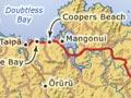
Mangōnui
Historic, picturesque township 36 km north-east of Kaitāia, on Doubtless Bay. The settlement and Taipā coast had a combined population of 1,662 in 2013.
Changing fortunes
Mangōnui was a favoured haven for whalers from the early 19th century. The township then grew as a trading port where kauri logs were milled and prepared for export. Farming started slowly too. By the 1860s Mangōnui was the administrative centre for the far north, with government offices, hotels, a hospital and coastal shipping links with Auckland.
Gum digging and flax milling boosted growth in the 19th century, but after 1900 kauri and gum business shifted west to Kaitāia. The administrative centre followed in 1918 and the hospital in 1934. The disappearance of the old industries and better roading led to Mangōnui’s decline as a coastal shipping port in the 1950s.
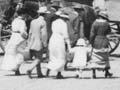
An impatient patient
A Northland woman was not happy with her treatment at Mangōnui hospital. When she received a bill, she responded: ‘I am sorry I cannot see my way at present to pay anything. Lucky I’m not dead, with the tinned milk, dried beans etc. I got when there. What with rates, taxes, soldier’s debts, bills etc. and a husband with not much work and plenty of swearing thrown in, I’m just about ready to keep company with His Satanic Majesty in the hot place, where I wish the Mangonui Hospital Board at present.’ 1
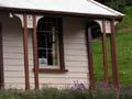
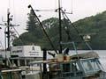
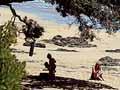
Mangōnui today
Mangōnui’s reputation as a fishing town attracts crowds to the food outlets along the harbour front. The whaling days are recorded in a small museum, while early buildings convey the sense of a time long past.
The town serves a farming district and permanent residents along the coast at Coopers Beach, Taipā and other bays. It also nurtures a growing tourist industry, with summer numbers swelling to many thousands.
Doubtless Bay
Bay west of Mangōnui, claimed as the site where the Polynesian explorer Kupe first landed. A monument at Taipā marks the spot of this landing, which led to Māori migration and settlement many years later. One tradition tells of an ancestral canoe being led in by a big shark (mangō nui), giving Mangōnui harbour and town its name.
The bay was visited by European explorers – Frenchman Jean François Marie de Surville and Englishman James Cook – in the 18th century. In December 1769 their ships were both in the area, unbeknown to each other. The bay was named by Cook – ‘Doubtless a bay’, he is reputed to have said on sighting it.
Karikari Peninsula
Distinctively shaped land mass on the east side of the Aupōuri Peninsula, separating Rangaunu Harbour from Doubtless Bay. The rocky outer part of Karikari was formerly an island. It is now joined to the mainland by accretion, which has formed Tokerau beach on the eastern side of the peninsula.
Karikari is a traditional homeland for Ngāti Kahu. One of their marae, Haiti-Tai-Marangai, is on the south coast of the peninsula at Whatuwhiwhi.
In December 1769 the bay was the site of violence between Māori and de Surville. His vessel, the St Jean Baptiste, lost three anchors off the peninsula. One is now at Kaitāia’s museum and another at the Museum of New Zealand Te Papa Tongarewa in Wellington. Grapes were planted on the northern coast of the peninsula in the late 1990s, and it is a popular tourist destination.