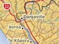
Dargaville
Town on the Northern Wairoa River, 58 km south-west of Whangārei and 186 km north-west of Auckland. In 2013 it had a population of 4,251.
The Wairoa (named ‘Northern’ to distinguish it from Wairoa in Hawke’s Bay) is the principal river feeding Kaipara Harbour from the north. Broad and straight for the 30 km of its course below Dargaville, it provided an easily navigable route into the kauri-forested interior. Dargaville is named for the Australian merchant Joseph Dargaville, who in 1872 bought the 80-ha Tunatahi block from the Ngāpuhi chief Parore Te Āwhā and others.
Timber
Like other Northern Wairoa settlements – Aoroa, Aratapu, Te Kopuru, Tokatoka and Ruāwai – Dargaville thrived as the kauri trees fell and the mills hummed. Dalmatians (Croatians), as well as locals and new arrivals from Britain, were drawn to the district.
Logs and timber were carried down the Wairoa River by ships of up to 3,000 tons which braved the Kaipara Harbour bar before making the journey to Onehunga, ports further south, and across the Tasman Sea to Australia – the biggest market.
Farming
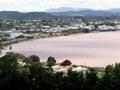
The timber and gum industries waned after 1920 but were replaced by farming, particularly dairying. South of Dargaville this occurs on the fertile Ruāwai flats. They are below sea level, but protected by drainage systems and stopbanks, and overlooked by a 180-m volcanic plug, Tokatoka.
Development since 1900
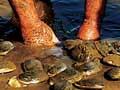
Dargaville became a borough (incorporated town) in 1908, and survived as the main centre of the district. It grew steadily until the 1960s, when the population stabilised. Named the ‘kūmara capital’ it is the country’s principal centre of kūmara (sweet potato) production. It lies on the approach to the ‘Kauri Coast’ tourist route, which leads to Waipoua and Hokianga.
Ripirō
100-km beach stretching from the 500-m Maunganui Bluff in the north to low-lying North Head at the entrance to Kaipara Harbour in the south. When most of inland Northland was covered in dense kauri forest, the west coast provided the best way to travel north and south.
Maunganui Bluff was an important landmark, visible many kilometres away in clear weather, especially from the south. It is often mentioned in oriori (chants) and waiata (songs) of the north. Landings of the ancestral canoes Māmari (at Ōmāmari) and Māhuhu-ki-te-rangi are also remembered.
Ripirō is today a gazetted highway, longer than the better-known Ninety Mile Beach on the Aupōuri Peninsula. The ‘road’ can be reached via the beach settlements along the coast – Aranga Beach, Ōmāmari, Baylys Beach and Glinks Gully.